The FLAG is made up of three municipalities (San Vicente de la Barquera, Comillas and Suances) in the region of Cantabria, in which protected areas represent 53% of the FLAG territory. The regions fishing fleet comprises 31 vessels with are mainly used for coastal fishing.
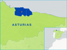
The Sidra FLAG, located in the mid-eastern part of Asturias, consists of five municipalities: Colunga, Bimenes, Cabranes, Nava and Villaviciosa. The area spans 570km2 which is approximately 5% of the Asturian region.
The FLAG territory is situated in the western part of the coastline in the North of Spain, facing the Bay of Biscay (in Spain referred to as Mar Cantabria). It is an area of high natural value, bordered in the west by the river Porcía and in the east by the municipality of Navia, the only city in the territory.
The FLAG area is situated in the western part of the Lublin region. It has very varied terrain, suitable for active tourism, and many protected areas. There are over 900 fish ponds.
The FLAG covers 18 municipalities located in the south-western part of Swietokrzyskie region. The FLAG area is mostly rural, with jobs located mainly in the towns of Jędrzejów, Małogoszcz, Sędziszów and Włoszczowa.
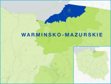
The FLAG is situated in the north-western part of the Warminsko-Mazurskie region, close to the border with Kaliningrad (Russia). The region is home to five small fishing ports and 62 fishing boats (compared to 220 about 10 years ago), usually owned by one or two fishermen. Fishing takes place in the brackish waters of the lagoon, where the main catch is herring but also bream and pikeperch.
The FLAG area is situated in the northern part of Wielkopolska, relatively close to big cities. It is rich in lakes, rivers, ponds and fishing grounds and there is good potential for rural tourism and recreational activities.
The FLAG area covers numerous lakes and forests. There are 89 fishing businesses, most of them involved in lake fishing (76), the others are aquaculture farms.
The FLAG area covers 20 municipalities and is of high natural value. Scenic landscapes with forests, hills and lakes attract a lot of tourism to the area, 60% of which is in the summer. Over 70% of the workforce is employed in agriculture (including fish farming).
The FLAG area is situated in the eastern part of Pomerania, on the Baltic Sea coast and the coast of the Vistula Lagoon. The fishing sector, including processing, harbour services and fish trade are important for the local economy.