The FLAG is located at the North-Eastern side of the Calabria region, close to the Gulf of Taranto. The area has important fish landing ports, fish processing enterprises and significant tourism potential, however there are challenges here linked to poor integration between sectors especially poor linkages between traditional fishing activities and tourism.
The FLAG covers the entire 130km coast of the Emilia-Romagna region. In this region fishing and lagoon fish farming have a tradition for centuries. The local economy is mainly based on fishing, aquaculture, mari-culture and summer coastal tourism.
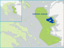
Lesvos is the third largest island in Greece and forms part of the North-East Aegean region. The island is rural and sparsely populated. The local economy is based on agricultural and fisheries activities. The island is known for olive oil, local dairy products, and fish.
Although the Region of Western Macedonia accounts for 60% of all of Greece’s water reserves, previous efforts at developing fisheries in the area have failed to gain traction.
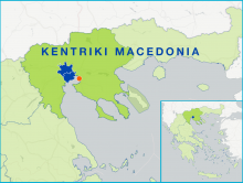
The FLAG area plays host to many important fisheries activities (including more than 60% of Greek mussel production). The main advantage the area has is its proximity to the large market of that the city of Thessaloniki offers. In general, however, fisheries here remain mostly small-scale.
The FLAG area comprises the lagoons of Vistonida, Ismarida, Porto Lagos, Aliki, Ptelea, Xirolimni and Karatza, parts of the Nestos and Kompsatos river basins and the coastline of Rodopi and Xanthi prefectures (up to 10 km inland).
The FLAG area is typical of Northern Brittany, combining a succession of rocky coastline, bays, river estuaries and marshes, as well as coastal towns strongly connected to a dynamic maritime environment. A great variety of ecosystems and scenery compose this area which is greatly influenced by the strong tides and harshness of the sea.
The Mariña-Ortegal FLAG is situated in northern Galicia covering 13 municipalities from two provinces. The area includes six estuaries and 16 ports, all of which have some level of fisheries activity. Ten of the ports have fish auctions, while four also have marinas.
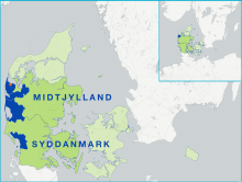
The FLAG area consists of four municipalities on the western coast of Jutland. They vary strongly in terms of population and economic activity. The region has both small and large scale fisheries activities.
The FLAG area is located in the North East of Schleswig Holstein on the Baltic Sea and is crossed by the River Schlei and its estuary. Both on the coast and on the river, there is strong fisheries tradition here.