FARNET
Fisheries Areas Network

Business support

  • Jurassic Fish FLAG

    08/09/2017
    - FLAG Factsheet
    The FLAG is located in the North-Eastern part of Silesia and most municipalities are part of the Polish Jurassic Highland. There are 35 fish farms, of which 12 are quite large (and have over 20 ha of fish ponds).
  • Valley of Tysmienica and Wieprz FLAG

    08/09/2017
    - FLAG Factsheet
    The FLAG is situated in the northern part of the Lublin region, and it is strongly diversified in terms of nature and landscape. Settlements in this area have historically been linked with lakes and fishing and most fish farms still use traditional methods such as the natural feeding of fish.
  • Sandomierz Forest FLAG

    08/09/2017
    - FLAG Factsheet
    The FLAG area is situated between the rivers Vistula and San and covers remnants of the ancient forests of Sandomierz and Janów Lubelski.
  • Fruit Trail FLAG

    08/09/2017
    - FLAG Factsheet
    The FLAG area is situated in the western part of the Lublin region. It has very varied terrain, suitable for active tourism, and many protected areas. There are over 900 fish ponds.
  • Suwalki-Augustow Lake District FLAG

    08/09/2017
    - FLAG Factsheet
    The FLAG area covers 20 municipalities and is of high natural value. Scenic landscapes with forests, hills and lakes attract a lot of tourism to the area, 60% of which is in the summer. Over 70% of the workforce is employed in agriculture (including fish farming).
  • Vistula Lagoon FLAG

    08/09/2017
    - FLAG Factsheet
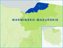
    The FLAG is situated in the north-western part of the Warminsko-Mazurskie region, close to the border with Kaliningrad (Russia). The region is home to five small fishing ports and 62 fishing boats (compared to 220 about 10 years ago), usually owned by one or two fishermen. Fishing takes place in the brackish waters of the lagoon, where the main catch is herring but also bream and pikeperch.
  • 7 Fish FLAG

    08/09/2017
    - FLAG Factsheet
    The FLAG area is situated in the northern part of Wielkopolska, relatively close to big cities. It is rich in lakes, rivers, ponds and fishing grounds and there is good potential for rural tourism and recreational activities.
  • Morenka FLAG

    08/09/2017
    - FLAG Factsheet
    The FLAG area covers numerous lakes and forests. There are 89 fishing businesses, most of them involved in lake fishing (76), the others are aquaculture farms.
  • Drawa and Walcz Leader Partnership FLAG

    08/09/2017
    - FLAG Factsheet
    The area has a long tradition and experience in fisheries, but the potential of lake fishing and pond farming is underutilised. The unique natural assets can be used to valorise new local products, such as smoked vendace from Drawa Lake District, which is available from many small producers.
  • Vistula Spit Fishing Community FLAG

    08/09/2017
    - FLAG Factsheet
    The FLAG area is situated in the eastern part of Pomerania, on the Baltic Sea coast and the coast of the Vistula Lagoon. The fishing sector, including processing, harbour services and fish trade are important for the local economy.