FARNET
Fisheries Areas Network

Business support

  • Terra d'Arneo multifund LAG

    25/09/2017
    - FLAG Factsheet
    The Terra d’Arneo territory spans the vicinity of the Apulian coast and operates a multi-fund Local Development Strategy (LDS). The area is characterised by small-scale traditional fishing enterprises. Seasonally the area has a strong tourism industry, while fishing activities are year-round.
  • South East Bari multifund LAG

    25/09/2017
    - FLAG Factsheet
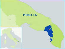
    The F/LAG area is located along 28 Km of the Adriatic coast and stretches 30 Km into the hinterland, in the South West of Bari province, The local economy is mostly based on agriculture, services and commerce. In the recent past tourism has been of growing importance as the Apulia region has become a popular touristic destination.
  • Trulli and Barsento multifund LAG

    25/09/2017
    - FLAG Factsheet
    The territory of the Trulli and Barsento F/LAG is situated within the Province of Bari and covers a total of eight municipalities. Only one of which, Monopoli, is a coastal city, located on the Adriatic coast of Apulia
  • Ponte Lama multifund LAG

    25/09/2017
    - FLAG Factsheet
    The F/LAG’s area covers about 20 Km of Apulian coastline along the Adriatic Sea to the north of Bari, including three municipalities Trani, Bisceglie and Molfetta (the last two were part of the Terre di Mare FLAG) . The coast is mainly rocky and calcareous, with some long sandy and pebble shores.
  • Stretto FLAG

    22/09/2017
    - FLAG Factsheet
    The area covers eleven municipalities in the province of Reggio Calabria and nine municipalities in the province of Vibo Valentina. The FLAG addresses the entire local community with the aim to raise the level of knowledge and skills for creating new professionalism and new small businesses in the area.
  • Castellamare and Carini gulfs FLAG

    22/09/2017
    - FLAG Factsheet
    Tourism is one of the main economic activities in the area including spa and beach tourism, underwater archaeology and fisheries-related tourism (itti-tourism and pesca-tourism). The fishing fleet consists of 306 small-scale fishing boats, of which many are below 12m in length.
  • West-South Sardinia FLAG

    22/09/2017
    - FLAG Factsheet
    The area of South Western Sardinia is characterised by a jagged coastline and long sandy shores; the area has many natural protected areas, such as the Carloforte and Sant’Antioco Isles. Inland the area has a strong cultural identity and heritage characterised by a longstanding mining industry
  • North Sardinia FLAG

    22/09/2017
    - FLAG Factsheet
    The North Sardinia FLAG runs for 931 km along the northern coast of the island which features a jagged coastline, small and sandy or rocky coves and only a few long stretches of beach. The north-eastern part of Sardinia is mostly mountainous with typical granite areas found in the Gallura region.
  • Due mari FLAG

    22/09/2017
    - FLAG Factsheet
    The FLAG area is situated in the southeast of Sicily and encompasses the provinces of Siracusa and Ragusa. The region has a strong agriculture and tourism sectors and a historical seafaring culture.
  • Golden Mile Coast FLAG

    22/09/2017
    - FLAG Factsheet
    The FLAG area stretches along the coastal strip overlooking the Gulf of Naples, and features strong views of the islands of Capri, Ischia and Procida throughout. Close to Naples, there is a significant amount of interaction between urban and coastal areas.