The FLAG area is situated along the border between the two municipalities of Halkidiki (Sithonias and Aristoteles). Its rural and mountainous geographic characteristics determine its economy and productive profile and have driven growth in the primary sector.
The area is very rural with thousands of years of history. There are many protected sites of natural beauty and the region attracts many tourists especially to the well-known island of Thassos. Fisheries in this area is mostly small-scale, complemented by some aquaculture and a limited amount large-scale fisheries activities.
Historically linked with the tobacco trade commerce as well as fish processing and retail, Kavala city is a beautiful amphitheatrical city open to Aegean Sea. The most important features of the area is the fisheries sector including small-scale and large-scale fishing.
The FLAG area comprises the lagoons of Vistonida, Ismarida, Porto Lagos, Aliki, Ptelea, Xirolimni and Karatza, parts of the Nestos and Kompsatos river basins and the coastline of Rodopi and Xanthi prefectures (up to 10 km inland).
The FLAG area is typical of Northern Brittany, combining a succession of rocky coastline, bays, river estuaries and marshes, as well as coastal towns strongly connected to a dynamic maritime environment. A great variety of ecosystems and scenery compose this area which is greatly influenced by the strong tides and harshness of the sea.
The Côte d’Emeraude – Rance – Baie du Mont Saint-Michel area surrounds the Rance river estuary. It is characterised by very contrasted landscapes: rocky shores, small rias stretching inland, marshes and polders. The territory relies on tourism, agriculture and maritime activities.
The Santa Pola FLAG is located in the South East of the Iberian Peninsula and covers the municipalities of Santa Pola and Guardamar. The main economic activities in both localities are fishing, aquaculture and tourism; salt production in salt lakes is also quite relevant.
The Mariña-Ortegal FLAG is situated in northern Galicia covering 13 municipalities from two provinces. The area includes six estuaries and 16 ports, all of which have some level of fisheries activity. Ten of the ports have fish auctions, while four also have marinas.
Kerteminde is located at the north-east of Denmark's second largest island Funen (Fyn), which situated between the island of Zealand and mainland Denmark (Jutland). The fishing industry has been under pressure for many years and its economic influence in society is declining. Despite this trend, new jobs have been created in the blue economy sector.
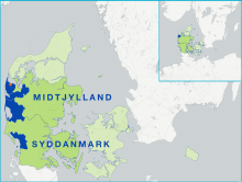
The FLAG area consists of four municipalities on the western coast of Jutland. They vary strongly in terms of population and economic activity. The region has both small and large scale fisheries activities.