FARNET
Fisheries Areas Network

Short circuits

  • Graciosa and Terceira

    09/04/2019
    - FLAG Factsheet
    The FLAG territory covers the islands of Terceira and Graciosa which are situated in the Central Group of the Azores archipelago and cover a total surface area of 403.6km2. The FLAG covers 126km of coastline on Terceira Island and 44km on Graciosa. Not dissimilar to most of the Azores, fisheries in the FLAG area and small-scale in nature.
  • Western Azores FLAG

    09/04/2019
    - FLAG Factsheet
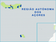
    The FLAG area covers the two most western islands of the Azores archipelago, Santa Maria and São Miguel. The area’s fisheries sector is characterised by traditional small-scale fisheries (mainly small siege, pole and long-line vessels). Common catches include small (mackerel and sardines) and large pelagic (tuna and swordfish) species, deep-water demersal, crustaceans and molluscs.
  • Farming and harvesting seaweed on the shore, on land and at sea

    18/03/2019
    - Cooperation Idea
    The Association of Professional Seaweed Harvesters of the Shores of Brittany (SRPARB) would like to exchange good practices and expertise between professionals.
  • map of the nine Festival del Mare along Emilia-Romagna coast at Adriatic Sea

    Fish festivals strengthen ties between fishermen and the community

    18/03/2019
    - Good Practice Project
    A series of festivals connects fishermen and aquaculture producers with the public, raising awareness of local fish, traditions and the marine habitat.
  • UK trainee chefs with Food Nation

    Social enterprise introduces seafood training programme for young chefs

    27/02/2019
    - Good Practice Short Story
    The North of Tyne FLAG has linked up with a local food NGO to deliver a programme aimed at inspiring young trainee chefs to use more seafood. The initiative is focused on raising the awareness and profile of local and lesser-known fisheries products, while also tackling youth unemployment.
  • Shabla - Kavarna - Balchik FLAG

    23/01/2019
    - FLAG Factsheet
    The FLAG territory has two geographically distinct areas, the coastal region to the east and the Dobrudzha plateau to the west. Fishing in the coastal areas, on the Black Sea, is traditional activity and important to the livelihood of many local communities. Fisheries are predominantly small-scale, accounting for approximately 90% of the sectors total employment.
  • From the fish auction to your plate

    19/09/2018
    - Good Practice Project
    Uus FLAG soosib gastronoomia, kohaliku toidu söömise ja kalanduse pärandi kokkusulatamist, toetades Gandia sadamas asuvat ebatavalist restorani.
  • Varna & Asparuhovo Area FLAG

    01/08/2018
    - FLAG Factsheet
    The FLAG territory covers the municipalities of Aksakovo, Beloslav and Asparuhovo which are situated on the Black Sea coast and near to the Varna Lake. The FLAG area is one of the most economically and socially developed regions in Bulgaria. Fishing, both coastal and inland, is mostly small-scale.
  • Tri Mora FLAG

    01/08/2018
    - FLAG Factsheet
    The Tri Mora FLAG is situated in the central part of Adriatic coast in Zadar County, under the Velebit mountain range and stretching over the Velebit channel.
  • Klaipeda-city FLAG

    31/07/2018
    - FLAG Factsheet
    The Klaipėda City FLAG is conveniently located near both the Baltic Sea and the Curonian Lagoon and includes part of the Curonian Spit National Park, the Swamp Back Island in the Curonian Lagoon and the Smiltynė Straight which connects the lagoon to the Black Sea.