The FLAG area covers the region of the northern part of the Amvrakikos gulf and the Ionian Sea in the Preveza prefecture. The area is well known for its environmental richness and hosts both a RAMSAR wetlands protection area and multiple Natura 2000 sites. Numerous avifauna, mammals, fish and vertebrate species are found here.
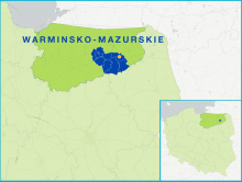
The FLAG is located in the Masurian Lakes region in north-eastern Poland. This area has a very high number of lakes – over 300, with a total surface of over 27 000 hectares, including the largest Polish lake, Śniardwy.
The FLAG is located in the inland part of the Pomeranian region and includes many lakes and rivers as well as fish farms. The rivers of the area are home to many valuable species of salmonid fish and, as such, offer excellent angling opportunities.
The FLAG is located on the Baltic sea coast north of the city of Gdańsk. The area has valuable natural assets, many of them protected. The main economic activities are tourism, fishing and fish processing.
The FLAG is situated on the Baltic Sea coast very close to the well-known Slowinski National Park. The area includes Leba, a fishing harbour with a small to medium-sized fishing fleet. Here we can also find fish processing as well as fish farming.
The Talsi FLAG is located in North Kurzeme, with a 54 km coastline along the Gulf of Riga. The FLAG area has a long history and tradition in fisheries. The activities of businesses are closely linked to the use of local natural resources
Lesvos is the third largest island in Greece and forms part of the North-East Aegean region. The island is rural and sparsely populated. The local economy is based on agricultural and fisheries activities. The island is known for olive oil, local dairy products, and fish.
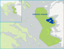
The FLAG area plays host to many important fisheries activities (including more than 60% of Greek mussel production). The main advantage the area has is its proximity to the large market of that the city of Thessaloniki offers. In general, however, fisheries here remain mostly small-scale.
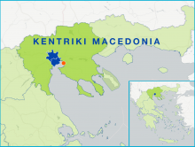
The FLAG area stretches between two gulfs on the Macedonian coast. Its main advantage is its proximity to the big market town of Thessaloniki. The type of fisheries found here ranges from small to medium scale. The area has one fishery harbour with a fish auction, three fishery shelters, and significant processing infrastructure.