FARNET
Fisheries Areas Network

Small-scale and coastal fisheries

  • La Plana FLAG

    12/09/2017
    - FLAG Factsheet
    The La Plana FLAG area covers the provinces of the three coastal regions of Baix Maestrat, Plana Alta and Plana Baixa. Fisheries and aquaculture only account for 5% of employment. Over a five-year period, fishing activity has reduced, and the number of active fishing vessels has decreased by more than 10%.
  • Menorca FLAG

    12/09/2017
    - FLAG Factsheet
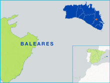
    Menorca is one of the Balearic Islands located in the Mediterranean Sea. The Menorca FLAG consists of eight municipalities which are Mahón, Ciutadella, Alayor, Es Mercadal, Ferreries, Es Castell, San Luis and Es Migjorn Gran. Tourism stands out as the main sector in the area accounting for 80% of the islands economic activity. Other industries include jewellery and traditional footwear.
  • Navia-Porcía FLAG

    12/09/2017
    - FLAG Factsheet
    The FLAG territory is situated in the western part of the coastline in the North of Spain, facing the Bay of Biscay (in Spain referred to as Mar Cantabria). It is an area of high natural value, bordered in the west by the river Porcía and in the east by the municipality of Navia, the only city in the territory.
  • Holderness FLAG --ARCHIVED as of 31 January 2020--

    12/09/2017
    - FLAG Factsheet
    --ARCHIVED as of 31 January 2020-- The Holderness Coast fisheries is a small scale coastal fisheries area specialising in crab and lobster. It is a vibrant industry which continues to grow and develop in the context of a struggling coastal economy traditionally dependant on seaside tourism.
  • Cornwall and Isles of Scilly FLAG --ARCHIVED as of 31 January 2020--

    12/09/2017
    - FLAG Factsheet
    --ARCHIVED as of 31 January 2020-- Cornwall and the Isles of Scilly lie at the very south-western tip of Britain and are home to some of the most unique coastal features in the United Kingdom. The fisheries sector here is very diverse and versatile in terms of methods and target species.
  • Vistula Lagoon FLAG

    08/09/2017
    - FLAG Factsheet
    The FLAG is situated in the north-western part of the Warminsko-Mazurskie region, close to the border with Kaliningrad (Russia). The region is home to five small fishing ports and 62 fishing boats (compared to 220 about 10 years ago), usually owned by one or two fishermen. Fishing takes place in the brackish waters of the lagoon, where the main catch is herring but also bream and pikeperch.
  • Great Masurian Lakes FLAG

    08/09/2017
    - FLAG Factsheet
    The FLAG is located in the north-western part of the Warmińsko-Mazurskie region. It is characterised by a high percentage of surface water (17% of the area). There are 119 lakes with a total area of around 34 000 hectares, as well as many forests and many protected areas.
  • Mielno FLAG

    08/09/2017
    - FLAG Factsheet
    The FLAG is located on the Baltic coast in the region of Western Pomerania. This area has a long tradition of small-scale fisheries whose boats are operated from the beach.
  • Szczecin Lagoon FLAG

    08/09/2017
    - FLAG Factsheet
    The FLAG is situated along the western part of the Polish Baltic sea coast close to the German border. It is an area very rich in fish (62 fish species, both marine and freshwater), with five fishing harbours. There are many small fishing boats and one fish processing plant.
  • Aude FLAG

    08/09/2017
    - FLAG Factsheet
    Fisheries activities have been long rooted in the FLAG area and, present in both its coastal waters and lagoons, are still closely associated with the local heritage. Indeed, it is the second French Mediterranean production area, hosting both fishing activities and shellfish farming.