FARNET
Fisheries Areas Network

Society and culture

  • Macin Branch FLAG

    14/09/2018
    - FLAG Factsheet
    The Macin Branch FLAG is in the western extremity of Tulcea county and males up roughly 12% of its total area. The Danube meadow forms the lowest part of FLAG area and comprises several wetlands which include pond and marsh habitats.
  • Satu Mare FLAG

    14/09/2018
    - FLAG Factsheet
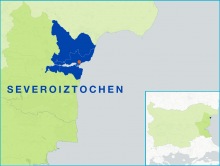
    The FLAG area covers the Satu Mare county in the northwest of Romania. It is partly made up of the Oaș mountain, which are part of the Eastern Carpathians. The remainder is hills, forming 20% of the area, and plains and the western county takes up the eastern part of the Pannonian plain. The FLAG area is crossed by the Someș, Tur, and Crasna rivers
  • Net mending: preserving tradition through diversification

    13/09/2018
    - Good Practice Short Story
    The net making profession has always been one of the least recognised professions within the fishing sector so several Galician net makers´ associations have brought it into the spotlight by combining dissemination workshops with a new range of products based on their unique know-how.
  • Enhancing native oyster stocks in Tralee Bay

    24/08/2018
    - Good Practice Project
    A fisheries cooperative embraces the use of new technology to ensure the sustainability of its native oyster stocks. By adopting spat collectors (“coupelles”) used in France, the Tralee Oyster Fisheries Society has offered a brighter future to its oyster fishers and the local tradition they represent.
  • Learning from fisher-led, marine plastic litter reduction initiatives

    22/08/2018
    - Cooperation Idea
    The Hastings FLAG is looking for experience, cases, solutions and actions taken to reduce marine litter in other parts of Europe and, in particular, in the Channel area and North Sea.
  • Nessebar - Messemvria FLAG

    01/08/2018
    - FLAG Factsheet
    The FLAG’s territory is a coastal area which includes 1.5km of beaches and 670m of sand dunes. The dunes are not just a natural phenomenon, they are specific environmental habitat and an important part of the area’s coastal landscape with great ecological significance.
  • Varna & Asparuhovo Area FLAG

    01/08/2018
    - FLAG Factsheet
    The FLAG territory covers the municipalities of Aksakovo, Beloslav and Asparuhovo which are situated on the Black Sea coast and near to the Varna Lake. The FLAG area is one of the most economically and socially developed regions in Bulgaria. Fishing, both coastal and inland, is mostly small-scale.
  • Pazardzhik FLAG

    01/08/2018
    - FLAG Factsheet
    The FLAG covers the Pazardzhik rural area but excludes the city of Pazardzhik. The landscape is mostly flat with some mountainous landscapes to the south. Running through the territory is the Maritsa River. Along the Maritsa are several micro dams and six aquaculture companies which are small enterprises using intensive floating cage techniques.
  • High Western Rhodopes FLAG

    01/08/2018
    - FLAG Factsheet
    The FLAG territory is situated in the southern part of Bulgaria (in the western part of the Rhodope Mountains). The mountainous area has several rivers, which are among the largest in Bulgaria. The region has a relatively low population density which is nearly three times lower than the national average.
  • Tri Mora FLAG

    01/08/2018
    - FLAG Factsheet
    The Tri Mora FLAG is situated in the central part of Adriatic coast in Zadar County, under the Velebit mountain range and stretching over the Velebit channel.