FARNET
Fisheries Areas Network

Environment

  • North West FLAG

    18/04/2017
    - FLAG Factsheet
    The FLAG North-West area is found along the coasts of counties Mayo, Sligo and Leitrim and comprises the 69 local electoral areas extending 10km from the coastline. Fishing and tourism are prominent within the coastal towns. There are 219 licenced registered fishing vessels in the area and 60% of these are day boats under eight metres in length.
  • Etruscan coast FLAG

    18/04/2017
    - FLAG Factsheet
    The FLAG area was selected based on the presence of significant fishing ports accommodating the fishing fleets operating in the maritime departments of Livorno and Portoferraio, which make use of the same fishing area and fish resources. In this area, the fishermen share markets, marketing methods and processing methods.
  • Åland FLAG

    11/04/2017
    - FLAG Factsheet
    The Åland Islands is an autonomous Swedish-speaking region of Finland which forms an archipelago in the Baltic Sea at the mouth of the Gulf of Bothnia between eastern Sweden and south western Finland. There are over 6 500 skerries and islands which make up the Åland Islands.
  • Lemesos FLAG

    10/04/2017
    - FLAG Factsheet
    The Lemesos FLAG is found in southern Cyprus and bordered by the district of Paphos and Larnaca. The FLAG area covers ten communities within the Limassol district and Municipality. Within the locality, the area of Amathus, in the Agios Tychonas community, is designated as a marine protected area for historical reasons.
  • Arcachon FLAG

    31/03/2017
    - FLAG Factsheet
    The Arcachon – Val de l’Eyre basin is a semi-closed bay where many marine activities take place, and in particular tourism, which is the key activity for the local economy. Fisheries and aquaculture are also important sectors in the area.
  • Ostrobothnia FLAG

    29/03/2017
    - FLAG Factsheet
    Ostrobothnia is narrow coastal area which forms part of the Kvarken archipelago. This archipelago of rocks and boulder clay was formed during the last ice-age, about 10 000 years ago and is subject to isostatic uplift of about 1 cm per year or 1 m per century.
  • Marennes Oléron FLAG

    17/03/2017
    - FLAG Factsheet
    The Marennes Oléron FLAG covers a rural and coastal territory whose natural and agricultural landscapes represent 85% of the area (40% of which are marshes). Tourism and primary sector activities are important components of the local economy, along with services and commercial activities.
  • clld020-scallop

    Cultivating Queen Scallops

    22/02/2017
    - Good Practice Project
    Scallop fishermen teamed up with scientists to study the possibility of cultivating Queen Scallops in the Vigo Estuary, diversifying their production method and improving the sustainability of their activity.
  • se-eu-map-sweden

    SE - FLAG Cooperation in Sweden

    02/02/2017
    - Cooperation MS Fiche
    The 2003-2013 period in Sweden saw a number of exchange visits with FLAGs from other Member States, including exchanges that led to projects to introduce new approaches to other countries. In 2014-2020, FLAG cooperation is not mandatory in Sweden, but FLAGs had to indicate in their strategies how much funding they planned to allocate to it.
  • Mondego Mar FLAG

    29/12/2016
    - FLAG Factsheet
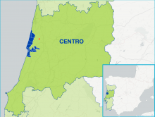
    The Mondego Mar FLAG is located in the centre of the Portuguese coastline and covers the municipalities of Cantanhede, Figueira da Foz, Mira and Montemor-o-Velho. This area is composed of marine, freshwater and estuarine ecosystems creating a complex and rich environment and hosting a range of fisheries activities, from aquaculture to shellfish harvesting to coastal fisheries.