FARNET
Fisheries Areas Network

Diversification

  • Solar energy, lighting up a remote landing site

    24/08/2018
    - Good Practice Short Story
    A local fisherman takes the initiative to explore how solar lighting might improve safety and make working hours more flexible at the remote pier where he lands his fish.
  • High Western Rhodopes FLAG

    01/08/2018
    - FLAG Factsheet
    The FLAG territory is situated in the southern part of Bulgaria (in the western part of the Rhodope Mountains). The mountainous area has several rivers, which are among the largest in Bulgaria. The region has a relatively low population density which is nearly three times lower than the national average.
  • Varna & Asparuhovo Area FLAG

    01/08/2018
    - FLAG Factsheet
    The FLAG territory covers the municipalities of Aksakovo, Beloslav and Asparuhovo which are situated on the Black Sea coast and near to the Varna Lake. The FLAG area is one of the most economically and socially developed regions in Bulgaria. Fishing, both coastal and inland, is mostly small-scale.
  • Pazardzhik FLAG

    01/08/2018
    - FLAG Factsheet
    The FLAG covers the Pazardzhik rural area but excludes the city of Pazardzhik. The landscape is mostly flat with some mountainous landscapes to the south. Running through the territory is the Maritsa River. Along the Maritsa are several micro dams and six aquaculture companies which are small enterprises using intensive floating cage techniques.
  • Istarska Batana FLAG

    01/08/2018
    - FLAG Factsheet
    The FLAG area is situated in the south of the Istrian peninsula. All local self-government units, apart from the Svetvinčenat municipality, are coastal. The area is very rich in historical and cultural heritage which to a large extent is linked with the sea and fisheries. A significant part of the area is under the protection of Natura 2000.
  • Istarski Svoj FLAG

    01/08/2018
    - FLAG Factsheet
    The FLAG’s territory extends along the west coast and in the inland part of the Istrian peninsula. As the FLAG area includes some of the most popular tourist destinations of the Upper Adriatic, tourism is the most important economic activity, relying on highly developed hotel and private sector capacities.
  • Plodovi Mora FLAG

    01/08/2018
    - FLAG Factsheet
    The FLAG area mainly comprises the islands of the coast of Zadar where agriculture, aquaculture and fisheries were historically primary sectors.
  • Ignalina FLAG

    31/07/2018
    - FLAG Factsheet
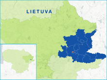
    The Ignalina FLAG territory is situated in the east of Lithuania, a region characterised by its many lakes and forests. As such, it has a high potential for the development of recreational, tourism and sports activities. Lakes occupy about 7.7% of the area, forests are about 33.7%, and woodland swamps approximately 10.7%.
  • Utena FLAG

    31/07/2018
    - FLAG Factsheet
    The Utena FLAG is situated to the east of Lithuania and is close to the Latvian border. The area has a naturally rich environment and comprises many lakes, forests, ponds, rivers, and streams and is a popular destination for national and international tourists. There are 182 lakes throughout the region making it a popular destination for water sports, cultural excursions and eco-tourism.
  • Zarasai-Visaginas FLAG

    31/07/2018
    - FLAG Factsheet
    The Zarasai and Visaginas region local action group is located in the north-east of Lithuania, in Utena county, on the border with Latvia and Belarus. The LAG territory is extremely rich in nature and pine woodland occupies nearly 30% of the LAG territory (around 51 thousand ha). 12.2% of the area is covered by around 300 water bodies. The total area of water bodies is about 13 000 ha.