FARNET
Fisheries Areas Network

Adding value to fisheries

  • Solar energy, lighting up a remote landing site

    24/08/2018
    - Good Practice Short Story
    A local fisherman takes the initiative to explore how solar lighting might improve safety and make working hours more flexible at the remote pier where he lands his fish.
  • Enhancing native oyster stocks in Tralee Bay

    24/08/2018
    - Good Practice Project
    A fisheries cooperative embraces the use of new technology to ensure the sustainability of its native oyster stocks. By adopting spat collectors (“coupelles”) used in France, the Tralee Oyster Fisheries Society has offered a brighter future to its oyster fishers and the local tradition they represent.
  • Nessebar - Messemvria FLAG

    01/08/2018
    - FLAG Factsheet
    The FLAG’s territory is a coastal area which includes 1.5km of beaches and 670m of sand dunes. The dunes are not just a natural phenomenon, they are specific environmental habitat and an important part of the area’s coastal landscape with great ecological significance.
  • Pazardzhik FLAG

    01/08/2018
    - FLAG Factsheet
    The FLAG covers the Pazardzhik rural area but excludes the city of Pazardzhik. The landscape is mostly flat with some mountainous landscapes to the south. Running through the territory is the Maritsa River. Along the Maritsa are several micro dams and six aquaculture companies which are small enterprises using intensive floating cage techniques.
  • Varna & Asparuhovo Area FLAG

    01/08/2018
    - FLAG Factsheet
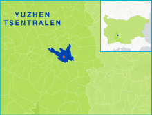
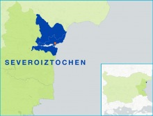
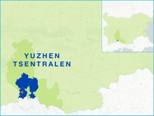
    The FLAG territory covers the municipalities of Aksakovo, Beloslav and Asparuhovo which are situated on the Black Sea coast and near to the Varna Lake. The FLAG area is one of the most economically and socially developed regions in Bulgaria. Fishing, both coastal and inland, is mostly small-scale.
  • High Western Rhodopes FLAG

    01/08/2018
    - FLAG Factsheet
    The FLAG territory is situated in the southern part of Bulgaria (in the western part of the Rhodope Mountains). The mountainous area has several rivers, which are among the largest in Bulgaria. The region has a relatively low population density which is nearly three times lower than the national average.
  • Tri Mora FLAG

    01/08/2018
    - FLAG Factsheet
    The Tri Mora FLAG is situated in the central part of Adriatic coast in Zadar County, under the Velebit mountain range and stretching over the Velebit channel.
  • Istarska Batana FLAG

    01/08/2018
    - FLAG Factsheet
    The FLAG area is situated in the south of the Istrian peninsula. All local self-government units, apart from the Svetvinčenat municipality, are coastal. The area is very rich in historical and cultural heritage which to a large extent is linked with the sea and fisheries. A significant part of the area is under the protection of Natura 2000.
  • Istarski Svoj FLAG

    01/08/2018
    - FLAG Factsheet
    The FLAG’s territory extends along the west coast and in the inland part of the Istrian peninsula. As the FLAG area includes some of the most popular tourist destinations of the Upper Adriatic, tourism is the most important economic activity, relying on highly developed hotel and private sector capacities.
  • Plodovi Mora FLAG

    01/08/2018
    - FLAG Factsheet
    The FLAG area mainly comprises the islands of the coast of Zadar where agriculture, aquaculture and fisheries were historically primary sectors.