FARNET
Fisheries Areas Network

Gastronomy

  • Elbe-Roeder Triangle FLAG

    07/11/2017
    - FLAG Factsheet
    The Elbe-Roeder-Dreieck FLAG is situated east of the river Elbe on the border between Brandenburg and Saxony. It is a rural region with a few focal points of large industry including steel and chemical plants. The landscape is characterised by high-value vineyards along the Elbe river and pond landscapes in the Roeder riverside floodplain. This area has been used for pond farming for about 300 years. The ponds were designed for purely economic reasons and served exclusively for carp pond farming.
  • Catering company set up by a barnacle gatherer and his mother

    02/10/2017
    - Good Practice Short Story
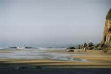
    Playa del Aguilar is a renowned beach and highly attractive touristic point on the Asturian coast. The village triples its population over the summer months, from 5 000 to 15 000 and the sandy beach and modern seafront are visited daily by thousands of tourists, summer residents and locals. However, in the vicinity of the beach, there are few restaurants or shops where tourists can buy ready-made food.
  • Hastings FLAG --ARCHIVED as of 31 January 2020--

    02/10/2017
    - FLAG Factsheet
    --ARCHIVED as of 31 January 2020-- Hastings fishing fleet is a small-scale beach launched fleet predominantly made up of boats under ten metres in length. The fishing techniques are generally selective.
  • South East Bari multifund LAG

    25/09/2017
    - FLAG Factsheet
    The F/LAG area is located along 28 Km of the Adriatic coast and stretches 30 Km into the hinterland, in the South West of Bari province, The local economy is mostly based on agriculture, services and commerce. In the recent past tourism has been of growing importance as the Apulia region has become a popular touristic destination.
  • Trulli and Barsento multifund LAG

    25/09/2017
    - FLAG Factsheet
    The territory of the Trulli and Barsento F/LAG is situated within the Province of Bari and covers a total of eight municipalities. Only one of which, Monopoli, is a coastal city, located on the Adriatic coast of Apulia
  • Trabocchi coast FLAG

    25/09/2017
    - FLAG Factsheet
    The FLAG’s coastal territory is of high environmental value. It is comprised of numerous villages, small towns and medium-size cities and has a significant number of ports.
  • West-Central Sardinia FLAG

    22/09/2017
    - FLAG Factsheet
    The West Central Sardinia FLAG area has a varied landscape of limestone cliffs and lowland sandy coasts which feature many wet habitats and lagoons.
  • Trapanese FLAG

    22/09/2017
    - FLAG Factsheet
    The FLAG area is situated in the western part of Sicily and the region’s economy is largely dependent on the sea. Fishing and canning are the two main local industries and fishers typically catch tuna using the ‘mattanza’ technique.
  • Blue Coast FLAG

    22/09/2017
    - FLAG Factsheet
    The Blue Coast FLAG area’s main features are the wide hill zone, interrupted by a big river valley, and several densely populated coastal towns. The sandy shore has a Mediterranean climate and scrub.
  • Friuli Venezia Giulia FLAG

    22/09/2017
    - FLAG Factsheet
    The FLAG area is characterised by a high-quality coastal and lagoon environment, hinterlands full of valuable historic centres. and a well-developed coast including resorts. Management systems for natural resources protection are present and oeno-gastronomical tourism is well developed.