FARNET
Fisheries Areas Network

Themes

19/05/2017
FLAG Factsheet
The FLAG is mainly characterised by widespread former brown-coal mining areas. In many of the opencast pits, artificial lakes have developed, which form a major part of the landscape in the area south of Leipzig in the north-west of the FLAG territory. The long history of mining and its legacy of pollution and environmental hazards are challenges these areas must cope with.
19/05/2017
FLAG Factsheet
The FLAG area is located in the North East of Schleswig Holstein on the Baltic Sea and is crossed by the River Schlei and its estuary. Both on the coast and on the river, there is strong fisheries tradition here.
17/05/2017
Cooperation Idea
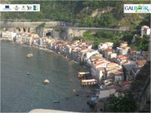
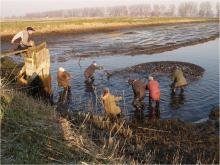
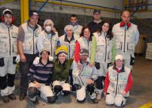
The dello Stretto FLAG from Italy wishes to compare current states of fishing techniques, storage, distribution, gastronomic traditions and land management as well as integrated development strategies for the coastal areas of project partners. careful analysis of these factors, starting from fishing grounds to the production places, can create added value for involved territories and cultures.
17/05/2017
FLAG Factsheet
Glückstadt is a town in the Steinburg district of Schleswig-Holstein, Germany. The FLAG area consists solely of the municipality of Glückstadt and is part of the LAG AktivRegion of Steinburg. Due to its location on the Elbe river on the way to Hamburg, its long tradition lies in fish processing, mainly herring, which is not caught in the FLAG area.
16/05/2017
FLAG Factsheet
The territory of VEGAC covers the entire coast between the mouth of the river Tagliamento (North) and the northern pier of the Port of Chioggia (South). Economically, the area developed since the seventies into a major seaside resort system characterized by tourist flows thanks to the large sandy shoreline north of the Venice lagoon and to the proximity to the historic city of Venice.
16/05/2017
FLAG Factsheet
The county of Dithmarschen is a rural and coastal area located on the west coast of Schleswig-Holstein. Within this area, the fishing communities of Büsum, Friedrichskoog, Marne and the municipality of Wöhrden, form the territory covered by the FLAG.
16/05/2017
FLAG Factsheet
The fisheries area “Nordfriesland Nord” is located on the west coast of Schleswig-Holstein, just under 20 km from the Danish border. It is a rural region with a strong tourism sector. In the immediate vicinity of the FLAG lie the North Frisian Islands of Sylt, Föhr and Amrum and the numerous Hallig islands (tidal islands).
11/05/2017
Good Practice Method
FLAG animation activities on a local fish farm have encouraged fish consumption, raised environmental awareness and launched new forms of local fish sales in the community.
11/05/2017
Good Practice Project
Coming from a long-established fishing family, André felt it was time to innovate their ways of utilizing the sea. He’s managed to do just that by setting up marine discovery tours in his traditional fishing village of Ferragudo, Portugal. Today, he shares his passion and knowledge of the local environment with the region’s tourists.
11/05/2017
Good Practice Project
The Mariña Ortegal FLAG has supported a social enterprise to create professional activities for the disabled and long-term unemployed, repairing plastic crates for the local fish auctions.