FARNET
Fisheries Areas Network

Themes

31/07/2018
FLAG Factsheet
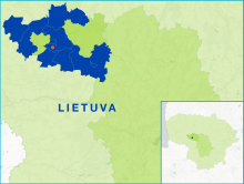
The Raseiniai FLAG is situated in the western part of Lithuania, in the northwest of Kaunas county, 76km northwest of Kaunas city. The territory is carved by rivers, streams and valleys; the rivers Dubysa, Šešuvis, Šaltuona, Mituva flow through the FLAG area.
31/07/2018
FLAG Factsheet
The Klaipėda City FLAG is conveniently located near both the Baltic Sea and the Curonian Lagoon and includes part of the Curonian Spit National Park, the Swamp Back Island in the Curonian Lagoon and the Smiltynė Straight which connects the lagoon to the Black Sea.
31/07/2018
FLAG Factsheet
The Neringa FLAG area is located between the Baltic Sea and the Curonian Lagoon. The city of Neringa was formed in 1961 and comprises a territory of eight separately administered areas, of which the central area is Nida. The city is situated in the Curonian Spit National Park and shares both a land and water border with the Russian exclave of Kaliningrad.
31/07/2018
FLAG Factsheet
The Šventoji FLAG area is characterised by a particularly attractive geographical location, exceptional nature, beaches that meet international standards and numerous cultural and natural heritage sites. Palanga is conveniently placed geographical, located 15km from the Latvian border, 25km north of Klaipėda railway station and 30km north of the Klaipėda international sea ferry terminal.
23/07/2018
Publication
FLAGs are in a strong position to support and encourage more inclusive local resource management processes. This guide is divided into five thematic factsheets to help FLAGs contribute to the development of a bottom-up approach to local resource management and support the conservation of local resources based on their specific contexts.
19/07/2018
Cooperation Idea
The Saint-Brieuc LEADER LAG and FLAG want to foster economic and tourism development in their area by making local products a lever to create tools for tourism, attract new visitors, improve the area's profile and enable local actors to work together. Through this cooperation project, the Saint-Brieuc LEADER LAG and FLAG aim to build, share and find development opportunities with its future partners; doing better together by drawing on shared experiences and good practices.
16/07/2018
FLAG Factsheet
The FLAG territory includes part of the Italian Riviera known as the Riviera dei Fiori, which runs from Diano Marina to Ventimiglia.
16/07/2018
FLAG Factsheet
The FLAG’s territory encompasses the coastline between Marina di Pisa and Marina di Carrara. Inland, the territory includes the regions of Lunigiana and Garfagnana which are predominantly mountainous and include Tuscany’s main aquaculture activities.
05/07/2018
Cooperation Idea
The Cyclades FLAG, Greece, is looking for partners to build a practical working group on fostering socio-economic development around MPAs. The idea is to bring together Mediterranean FLAGs that are home to a Marine Protected Area to exchange and discuss ways to ensure MPAs are successful in protecting biodiversity while remaining economically viable. Participating FLAGs would take turns to organise and host a workshop and case study on the topic, starting in early 2019. Read on for further details.
04/07/2018
Event
FARNET's 7th transnational seminar took place on 20-22 November 2018 in Saint-Jean-de-Luz, France. It offered FLAGs an opportunity to better understand what circular economy is and to exchange on different types of initiatives they might support to encourage more sustainable local production and consumption habits: based on reducing waste, re-using products and recycling materials.