FARNET
Fisheries Areas Network

Infrastructure

  • Pomorie FLAG

    23/01/2019
    - FLAG Factsheet
    The FLAG territory is in the south-east planning region of Bulgaria. The region has a strong fisheries tradition, though fisheries jobs only account for approximately 1% of the area’s total employment. However, many local fishers also engage in other occupations and activities such as tourism and services.
  • Bulgarian Black Sea Agreement Byala-Dolni chiflik-Avren

    23/01/2019
    - FLAG Factsheet
    The FLAG territory includes 45km of the Black Sea coast in Varna Province, equating to approximately 13% of the Bulgarian Black Sea coastline. The leading industries in the area are tourism and agriculture. Fisheries in the region are small-scale and important in the local population – roughly 5% of the economically active population are engaged in fisheries.
  • Shabla - Kavarna - Balchik FLAG

    23/01/2019
    - FLAG Factsheet
    The FLAG territory has two geographically distinct areas, the coastal region to the east and the Dobrudzha plateau to the west. Fishing in the coastal areas, on the Black Sea, is traditional activity and important to the livelihood of many local communities. Fisheries are predominantly small-scale, accounting for approximately 90% of the sectors total employment.
  • Becoming self-sufficient through renewables

    17/12/2018
    - Good Practice Short Story
    The fishing organisation of Bustio has become the first in Spain to become self-sufficient in renewable energy for its on land operations. By making an environmental commitment to reduce carbon emissions, it is saving around €10 000 a year on electricity.
  • FLAG builds bridges between local fishermen and municipality to regenerate port of Puise

    12/12/2018
    - Good Practice Project
    Puise has become a thriving coastal fishing port in Läänemaa after a regeneration project supported by the local FLAG.
  • From the fish auction to your plate

    19/09/2018
    - Good Practice Project
    A new FLAG supports the fusion of gastronomy, “eating local” and fisheries heritage by supporting an atypical restaurant in the port of Gandía.
  • Pazardzhik FLAG

    01/08/2018
    - FLAG Factsheet
    The FLAG covers the Pazardzhik rural area but excludes the city of Pazardzhik. The landscape is mostly flat with some mountainous landscapes to the south. Running through the territory is the Maritsa River. Along the Maritsa are several micro dams and six aquaculture companies which are small enterprises using intensive floating cage techniques.
  • Tri Mora FLAG

    01/08/2018
    - FLAG Factsheet
    The Tri Mora FLAG is situated in the central part of Adriatic coast in Zadar County, under the Velebit mountain range and stretching over the Velebit channel.
  • Istarski Svoj FLAG

    01/08/2018
    - FLAG Factsheet
    The FLAG’s territory extends along the west coast and in the inland part of the Istrian peninsula. As the FLAG area includes some of the most popular tourist destinations of the Upper Adriatic, tourism is the most important economic activity, relying on highly developed hotel and private sector capacities.
  • Western Lithuania FLAG

    31/07/2018
    - FLAG Factsheet
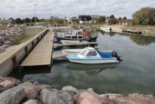
    The FLAG is situated in the western part of Lithuania, near the Curonian Lagoon. The region is well known for covering a large variety of water bodies and is aptly called ‘the land of four waters’ as a result. As well as the Curonian Lagoon, these waters also include the Baltic Sea it is surrounded by the Baltic Sea and several lakes, rivers, ponds, quarries suitable for recreational fishing.