Tourism is one of the main economic activities in the area including spa and beach tourism, underwater archaeology and fisheries-related tourism (itti-tourism and pesca-tourism). The fishing fleet consists of 306 small-scale fishing boats, of which many are below 12m in length.
The FLAG territory comprises a diverse coastline and sandy dunes and is characterised by several delicate ecosystems. The region is a major tourist destination due to its rich archaeological history.
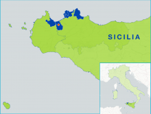
The FLAG area is situated in the southeast of Sicily and encompasses the provinces of Siracusa and Ragusa. The region has a strong agriculture and tourism sectors and a historical seafaring culture.
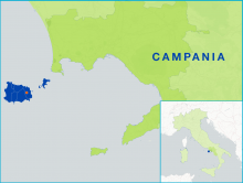
The FLAG area which consists of the Ischia, Procida and Vivara isles covers an area of approximately 75km2. The surrounding seabeds are characterised by vast posidonia meadows, a seaweed endemic to the Mediterranean Sea, which is home to many species of fishes. As a result, fishing has always been a very important activity in the area.
The FLAG is situated in the Southern part of the Marche region, bordering with the Abruzzo region at the mouth of the Tronto river. It is a discontinuous area of five municipalities (from north to south- Porto San Giorgio, Pedaso, Cupra Marittima, Grottammare and San Benedetto del Tronto).
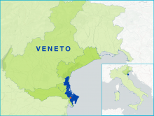
The FLAG area has remained unchanged compared to Axis 4, and includes four municipalities (Chioggia, Rosolina, Porto Viro and Porto Tolle) in the provinces of Venice and Rovigo.
The FLAG area is included in three provinces and seven municipalities. Fishing activities on the Sicilian islands are mainly small-scale and coastal. Their challenges include poorly developed infrastructure in landing areas, a lack of real fish markets and a low number of processing facilities.
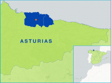
The Sidra FLAG, located in the mid-eastern part of Asturias, consists of five municipalities: Colunga, Bimenes, Cabranes, Nava and Villaviciosa. The area spans 570km2 which is approximately 5% of the Asturian region.
The FLAG is located between the Danube and Olt rivers and benefits from various fishing and aquaculture resources that allow opportunities for activities such as tourism or sport fishing.
--ARCHIVED as of 31 January 2020-- Cornwall and the Isles of Scilly lie at the very south-western tip of Britain and are home to some of the most unique coastal features in the United Kingdom. The fisheries sector here is very diverse and versatile in terms of methods and target species.