FARNET
Fisheries Areas Network

Education and training

  • Trégor & Guingamp FLAG

    08/09/2017
    - FLAG Factsheet
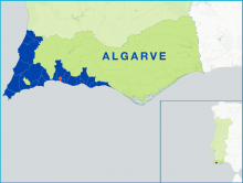
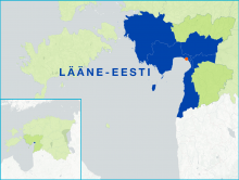
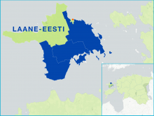
    Maritime activities (fishing, aquaculture, harbour and nautical activities) are at the heart of the economy of the FLAG area which also includes renewable marine energies, coastal agriculture (mainly vegetables), and strong tourism activities based on remarkable landscapes. The territory features a very active cultural life.
  • West Normandy FLAG

    08/09/2017
    - FLAG Factsheet
    With its 460km of coastline, made up of harbours, bays, cliffs and long beaches, the West Normandy FLAG area has a wealth of coastal resources. It is an area with an important primary sector and a high production of fish and shellfish.
  • Skåne Nordväst Norra FLAG

    08/09/2017
    - FLAG Factsheet
    Fishing on the Swedish side of the Öresund strait consists almost exclusively of local small-scale coastal fisheries providing unique opportunities for local fisheries development. The revenue from the Öresund area is among the highest in Sweden and the fish stocks amongst the strongest.
  • Lake Vänern FLAG

    08/09/2017
    - FLAG Factsheet
    Lake Vänern is the largest lake in Sweden. Challenges for the region include an ageing population, particularly in fisheries communities.
  • Teaching young people about fisheries

    08/09/2017
    - Good Practice Short Story
    One of the main needs identified by the Galati FLAG in their fisheries area was to strengthen the linkages between fishermen and the younger generation. Indeed, fishermen believed it important to ensure that traditional fishing know-how and their passion for the profession were passed on to the next generation.
  • Gästrikebygden FLAG

    08/09/2017
    - FLAG Factsheet
    The FLAG area includes the coast, rivers, and lakes along the Gulf of Bothnia, roughly 200km north of Stockholm. The landscape is dominated by pine woodlands and many inhabitants live in smaller towns and in rural areas.
  • Barlavento do Algarve FLAG

    05/09/2017
    - FLAG Factsheet
    The Barlavento do Algarve FLAG area is in the southwest of Portugal and has strong links to the sea in terms of both fishing and tourism. The main challenges for the FLAG include the sustainable re-establishment of small-scale fisheries in the area which suffered from the impacts of sectoral restructuring at national and community level over the past two decades.
  • Parnu FLAG

    05/09/2017
    - FLAG Factsheet
    Located in the south-west of Estonia, the FLAG area is situated around the Pärnu Gulf. The largest of the Estonian counties, Pärnu geographically covers 10.6% of the Estonian mainland and a total of 177 islands; of which only two, Kihnu and Manija, are inhabited.
  • Saaremaa FLAG

    05/09/2017
    - FLAG Factsheet
    The Saaremaa FLAG covers the islands of western Estonia in Saare county, with exception of Hiiumaa which has its own FLAG. The biggest islands in the Saaremaa FLAG area are Saaremaa, Muhu, Ruhnu, and Abruka ja Vilsandihe.
  • Hiiukala FLAG

    05/09/2017
    - FLAG Factsheet
    Hiiumaa is a beautiful un-spoilt island in the Baltic sea to the west of Estonia which can be reached in about 90 minutes by ferry from the mainland. The FLAG area consists of Hiiumaa island and a number of small islets surrounding it which together form the county of Hiiu. This county is divided into five municipalities, of which four are part of the FLAG.