FARNET
Fisheries Areas Network

Pesca-tourism

  • Bohuskust FLAG

    08/09/2017
    - FLAG Factsheet
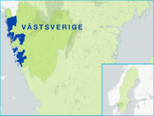
    The Bohuslän region is strongly linked to the oceans and fisheries which have for more than 500 years been a source of sustenance and livelihood for local inhabitants. At the same time, seasonal dwellers, tourists and other visitors enjoy the fantastic landscape where fishing and environmental concerns are paramount.
  • Lake Vättern FLAG

    08/09/2017
    - FLAG Factsheet
    The FLAG area covers the whole lake Vättern, which is the second largest lake in Sweden. There are around 20 commercial small-scale fishermen and the species of greatest economic value is crayfish.
  • Halland FLAG

    08/09/2017
    - FLAG Factsheet
    Halland is a coastal area characterised by many sandy beaches, rockfaces, lakes and rivers. In the northern part of the FLAG area is the archipelago, which is largely protected by nature reserves.
  • Lake Vänern FLAG

    08/09/2017
    - FLAG Factsheet
    Lake Vänern is the largest lake in Sweden. Challenges for the region include an ageing population, particularly in fisheries communities.
  • Barlavento do Algarve FLAG

    05/09/2017
    - FLAG Factsheet
    The Barlavento do Algarve FLAG area is in the southwest of Portugal and has strong links to the sea in terms of both fishing and tourism. The main challenges for the FLAG include the sustainable re-establishment of small-scale fisheries in the area which suffered from the impacts of sectoral restructuring at national and community level over the past two decades.
  • ecoMAR FLAG

    05/09/2017
    - FLAG Factsheet
    The FLAG area extends over a coastal area of 35km and covers five parishes in two municipalities. This territory is noted for its traditional small-scale fisheries. This is a predominantly agricultural area with a growing tourist sector thanks to its accessible beaches.
  • Hiiukala FLAG

    05/09/2017
    - FLAG Factsheet
    Hiiumaa is a beautiful un-spoilt island in the Baltic sea to the west of Estonia which can be reached in about 90 minutes by ferry from the mainland. The FLAG area consists of Hiiumaa island and a number of small islets surrounding it which together form the county of Hiiu. This county is divided into five municipalities, of which four are part of the FLAG.
  • Karpfenland Aischgrund FLAG

    01/09/2017
    - FLAG Factsheet
    The Aischgrund FLAG is strongly influenced by the area’s fishponds. There are currently around 7000 ponds, where approximately 1200 farmers produce 15% of the total carp production in Germany in small-scale fisheries. The carp is not only a significant economic factor but also a significant part of the ecology and the culture with a 1200-year-old tradition
  • Karpfenland Romantic Franconia FLAG

    01/09/2017
    - FLAG Factsheet
    The FLAG covers the administrative region of Middle Franconia, the largest rural district in Bavaria. Ansbach is the main city in the area which is situated 25 miles southwest of Nuernberg, 90 miles north of Munich and is near the Franconian Lake District.
  • Hills of the Baltic Sea beach FLAG

    31/08/2017
    - FLAG Factsheet
    The coastal and inland rural area of “Hügelland am Ostseestrand” is located on the Baltic coast of Schleswig-Holstein around the Bay of “Eckernförde”, an important fisheries area. It is close to Kiel; the capital of Schleswig-Holstein and the Kiel canal borders the region in the south.