FARNET
Fisheries Areas Network

Gastronomy

  • Parnu FLAG

    05/09/2017
    - FLAG Factsheet
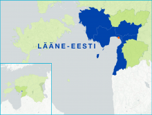
    Located in the south-west of Estonia, the FLAG area is situated around the Pärnu Gulf. The largest of the Estonian counties, Pärnu geographically covers 10.6% of the Estonian mainland and a total of 177 islands; of which only two, Kihnu and Manija, are inhabited.
  • West Mecklenburg Baltic Sea coast FLAG

    01/09/2017
    - FLAG Factsheet
    Open natural areas, idyllic villages, extensive avenues, castles and manor houses dominate the landscape. The economy of this area traditionally consisted of agriculture, the food industry and tourism.
  • Dresdner Heidebogen FLAG

    01/09/2017
    - FLAG Factsheet
    The FLAG’s territory is situated to the east of Saxony and borders the regions of Dresden to the south and Brandenburg to the north. The eastern part of the area is highly forested, while the west is characterised by a typically European agricultural landscape. Throughout the entire area, pond farming is prevalent.
  • Lusatian Lake District FLAG

    01/09/2017
    - FLAG Factsheet
    The Oberlausitzer Heide und Teichlandschaft in the south of the region is one of the biggest commercially used lakelands in Germany. Here, there are 1,925 hectares of lakes with an economic use.
  • Karpfenland Romantic Franconia FLAG

    01/09/2017
    - FLAG Factsheet
    The FLAG covers the administrative region of Middle Franconia, the largest rural district in Bavaria. Ansbach is the main city in the area which is situated 25 miles southwest of Nuernberg, 90 miles north of Munich and is near the Franconian Lake District.
  • Karpfenland Aischgrund FLAG

    01/09/2017
    - FLAG Factsheet
    The Aischgrund FLAG is strongly influenced by the area’s fishponds. There are currently around 7000 ponds, where approximately 1200 farmers produce 15% of the total carp production in Germany in small-scale fisheries. The carp is not only a significant economic factor but also a significant part of the ecology and the culture with a 1200-year-old tradition
  • Delitzsch area FLAG

    01/09/2017
    - FLAG Factsheet
    The Delitzscher region is situated in the north of Saxony, in western “Nordsachsen” to the north of the city of Leipzig. 72% of the area is used for agricultural purposes and 1,933 ha is covered in water
  • Southern North Friesland FLAG

    31/08/2017
    - FLAG Factsheet
    The fisheries area “Nordfriesland Nord” is located on the west coast of Schleswig-Holstein, just under 20 km from the Danish border. It is a rural region with a strong tourism sector. In the immediate vicinity of the FLAG lie the North Frisian Islands of Sylt, Föhr and Amrum and the numerous Hallig islands (tidal islands). The North Sea in this area is part of the German Wadden Sea National Park of Schleswig-Holstein which is a UNESCO World Heritage Site.
  • Paphos FLAG

    31/08/2017
    - FLAG Factsheet
    The area has an excellent climate, is rich in natural resources and landscapes, and has a rare flora and fauna. The fisheries sector in the area is considered particularly important because it creates jobs and offers healthy products to the people.
  • Virumaa FLAG

    28/08/2017
    - FLAG Factsheet
    The FLAG area is located on the Northern and North-Eastern coast of Estonia. Small-scale coastal fishing of mostly flounder, perch and salmon is the main activity of local fishermen. This fish is mainly marketed directly to end consumers.