FARNET
Fisheries Areas Network

Gastronomy

  • Istria FLAG

    12/09/2017
    - FLAG Factsheet
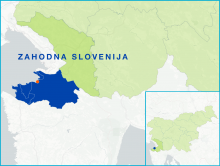
    The coastal area of Slovenia includes the coastal part of four municipalities: Ankaran, Izola, Koper, Piran, which border the Gulf of Trieste in the northernmost part of the Adriatic Sea. The Slovenian coastline measures only 46.6 km and the total value of the catch here represents only 0.01% of national GDP. However, the fishing sector is very important for the area’s economy and the preservation of workplaces, culture, traditions and local identity.
  • Ebro FLAG

    12/09/2017
    - FLAG Factsheet
    The Ebro FLAG operates on the Mediterranean coast, in the south of Catalonia. It borders with Aragon to the West and the region of Valencia to the south. The municipalities covered are located along the final stretch of the Ebro river, in the unique setting of the Ebro Delta. The most important port in the area is Sant Carlos de la Ràpita.
  • Bajo Nalón FLAG

    12/09/2017
    - FLAG Factsheet
    The Bajo Nalón FLAG area is made up of just two municipalities (Muros de Nalón and Soto del Barco) in the Asturian region. This area also includes the Nalón river, the largest and most important river of the Spanish northern coast. Both municipalities are located at the mouth of the Nalón river.
  • Vistula Lagoon FLAG

    08/09/2017
    - FLAG Factsheet
    The FLAG is situated in the north-western part of the Warminsko-Mazurskie region, close to the border with Kaliningrad (Russia). The region is home to five small fishing ports and 62 fishing boats (compared to 220 about 10 years ago), usually owned by one or two fishermen. Fishing takes place in the brackish waters of the lagoon, where the main catch is herring but also bream and pikeperch.
  • Sea and Parseta River FLAG

    08/09/2017
    - FLAG Factsheet
    The FLAG area is situated in Western Pomerania in the county of Kołobrzeg. The Parsęta river flows through the area and at its estuary there is a harbour with many functions including trade, fishing, passenger traffic etc.
  • Lake Vättern FLAG

    08/09/2017
    - FLAG Factsheet
    The FLAG area covers the whole lake Vättern, which is the second largest lake in Sweden. There are around 20 commercial small-scale fishermen and the species of greatest economic value is crayfish.
  • Sydost FLAG

    08/09/2017
    - FLAG Factsheet
    The FLAG area is situated in the southeast of Sweden and features numerous lakes, streams, coasts and seas, forming a unique development area. Challenges for the area include the low added value of local fisheries products.
  • Stockholmsbygd FLAG

    08/09/2017
    - FLAG Factsheet
    The area stretches over a cluster of some 30,000 sparsely populated islands and a small portion of the mainland’s countryside. It forms part of the commuter belt of Sweden’s capital city with the resulting high property prices, frequent ferry crossings and other commuter traffic that this can bring.
  • Barlavento do Algarve FLAG

    05/09/2017
    - FLAG Factsheet
    The Barlavento do Algarve FLAG area is in the southwest of Portugal and has strong links to the sea in terms of both fishing and tourism. The main challenges for the FLAG include the sustainable re-establishment of small-scale fisheries in the area which suffered from the impacts of sectoral restructuring at national and community level over the past two decades.
  • Parnu FLAG

    05/09/2017
    - FLAG Factsheet
    Located in the south-west of Estonia, the FLAG area is situated around the Pärnu Gulf. The largest of the Estonian counties, Pärnu geographically covers 10.6% of the Estonian mainland and a total of 177 islands; of which only two, Kihnu and Manija, are inhabited.