FARNET
Fisheries Areas Network

Promotion

  • Blue Coast FLAG

    22/09/2017
    - FLAG Factsheet
    The Blue Coast FLAG area’s main features are the wide hill zone, interrupted by a big river valley, and several densely populated coastal towns. The sandy shore has a Mediterranean climate and scrub.
  • North Marche FLAG

    22/09/2017
    - FLAG Factsheet
    The FLAG area lies along the northern coast of the Marche region, covers five municipalities (Gabbice Mare, Pesaro, Fano, Mondolfo and Senigallia) and has Axis 4 experience.
  • Sicily Islands FLAG

    14/09/2017
    - FLAG Factsheet
    The FLAG area is included in three provinces and seven municipalities. Fishing activities on the Sicilian islands are mainly small-scale and coastal. Their challenges include poorly developed infrastructure in landing areas, a lack of real fish markets and a low number of processing facilities.
  • East Liguria FLAG

    13/09/2017
    - FLAG Factsheet
    The East Liguria FLAG area covers all coastal municipalities of the provinces of Genoa and La Spezia, and is characterised by a geographical continuity and economical homogeneity based on micro and small businesses (mostly engaged in the trade and tourism sector).
  • El Hierro FLAG

    12/09/2017
    - FLAG Factsheet
    El Hierro is the smallest and most westerly island of the Canary archipelago. The FLAG area consists of the municipalities of La Frontera, El Pinar and Valverde, covers an area of approximately 270km2, and has a population of 10 000.
  • La Palma FLAG

    12/09/2017
    - FLAG Factsheet
    La Palma is one of the Canary Islands located in the Atlantic Sea. The FLAG consists of 14 municipalities, covers an area of approximately 710km2, and has a population of roughly 80 000 inhabitants.
  • Noroeste de Cádiz FLAG

    12/09/2017
    - FLAG Factsheet
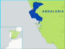
    The Noroeste de Cádiz FLAG area consists of five municipalities: Trebujena, Sanlúcar de Barrameda, Rota, Chipiona and Puerto de Santa María. Fishing activities (trawling, seining, shell-fishing) are widespread throughout the area where there are several fishing ports and catches are sold at fish auctions daily.
  • Gran Canaria FLAG

    12/09/2017
    - FLAG Factsheet
    The FLAG covers the coastline of Gran Canaria, the most populated of the seven Canary Islands. Tourism is the main engine of Gran Canaria’s economy, 63% of which is divided between the retail trade and the restaurant sector.
  • Fuerteventura FLAG

    12/09/2017
    - FLAG Factsheet
    The island of Fuerteventura is the second largest of the Canary Islands and includes the 4.8Km2 islet of Lobos. It has a low, sandy coastline resulting from intense erosion. The activities that traditionally occupied the local population (agriculture, including cattle farming, and fishing) now provide employment to scarcely 1.2% of the population, while three quarters of jobs are linked to the service sector, and in particular tourism.
  • Ibiza FLAG

    12/09/2017
    - FLAG Factsheet
    Ibiza and Formentera, known as the Pitiusas Islands, are located at the western edge the Balearic archipelago, in the Mediterranean Sea. The economy of Ibiza and Formentera is characterised by a notable tourism sector.