Kerry is one of the most sparsely populated counties in Ireland with the most rural and peripheral areas in the county experiencing declining populations over the last 20 years. This is especially true of the coastal regions.
Donegal is a large county with a lengthy coastline featuring a number of long inlets and bays. The region is sparsely populated and outside of Letterkenny, its only large urban centre, there is a high dependence on small-scale agriculture and fisheries enterprises.
The Danube Delta FLAG area comprises 25 administrative units and covers two contrasting geographical zones: the wetland of the Danube delta and the continental zone. The most valuable opportunities in the FLAG area include its significant tourist potential due to its traditional gastronomy and an impressive variety of beautiful natural and cultural landscapes.
The area includes the coast of the Ilia prefecture and the Pinios Lake and is located along the western half of the Peloponnese peninsula. The fisheries activities found here are mostly small-scale.
The FLAG area is situated in western Greece, in the north-western part of the Peloponnese peninsula. A very large part of the coastal economy is indirectly dependent on fishing, as many activities such as tourism, food services and commerce benefit from marine products.
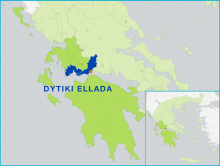
The FLAG area consists of a combination of mountainous and coastal landscapes. It possesses Greece’s largest lagoon (the Messolonghi lagoon). Most of the fishing activity is small-scale and traditional and takes place in the Messolonghi lagoon.
The area includes the South West coast of Aitoloakarnania, the Meganisi island and a large number of lakes (five natural and three artificial) on the mainland. The most common type of fishing is small-scale coastal. Aquaculture is also a very important activity in the area.
The FLAG area lies in Eastern Macedonia, near the Turkish border. It can be characterised economically by the development of tourism, especially on the island of Samothraki.
The FLAG is located on the Baltic sea coast. It has many valuable assets, in particular its nature, landscape and culture. The fisheries sector, together with tourism, play and important role in the economy.
The valley of the Barycz river is situated in south-western Poland at the border of Lower Silesia and Wielkopolska. It has an 800 year-long tradition in carp production in ponds.