The FLAG area comprises the lagoons of Vistonida, Ismarida, Porto Lagos, Aliki, Ptelea, Xirolimni and Karatza, parts of the Nestos and Kompsatos river basins and the coastline of Rodopi and Xanthi prefectures (up to 10 km inland).
The FLAG area is typical of Northern Brittany, combining a succession of rocky coastline, bays, river estuaries and marshes, as well as coastal towns strongly connected to a dynamic maritime environment. A great variety of ecosystems and scenery compose this area which is greatly influenced by the strong tides and harshness of the sea.
The Côte d’Emeraude – Rance – Baie du Mont Saint-Michel area surrounds the Rance river estuary. It is characterised by very contrasted landscapes: rocky shores, small rias stretching inland, marshes and polders. The territory relies on tourism, agriculture and maritime activities.
The Santa Pola FLAG is located in the South East of the Iberian Peninsula and covers the municipalities of Santa Pola and Guardamar. The main economic activities in both localities are fishing, aquaculture and tourism; salt production in salt lakes is also quite relevant.
The FLAG area is located in the North East of Schleswig Holstein on the Baltic Sea and is crossed by the River Schlei and its estuary. Both on the coast and on the river, there is strong fisheries tradition here.
The territory of VEGAC covers the entire coast between the mouth of the river Tagliamento (North) and the northern pier of the Port of Chioggia (South). Economically, the area developed since the seventies into a major seaside resort system characterized by tourist flows thanks to the large sandy shoreline north of the Venice lagoon and to the proximity to the historic city of Venice.
Coming from a long-established fishing family, André felt it was time to innovate their ways of utilizing the sea. He’s managed to do just that by setting up marine discovery tours in his traditional fishing village of Ferragudo, Portugal. Today, he shares his passion and knowledge of the local environment with the region’s tourists.
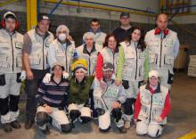
The Mariña Ortegal FLAG has supported a social enterprise to create professional activities for the disabled and long-term unemployed, repairing plastic crates for the local fish auctions.
The local fishing sector is made up of small-scale inshore operations and shellfish gathering. The only oyster farms in Asturias are also located in this territory. Other relevant economic activities carried out in the FLAG´s territory are agriculture and rural tourism.
The Golfo Ártabro Norte FLAG is situated in the northeast of Galicia. It includes ten municipalities located north of the (“Golfo”) Ártabro Bay, more specifically those around the rias of Betanzos, Ares and Ferrol. The territory has 10 landing points with basic facilities used daily by around 250 small-scale traditional fishing boats. In addition, shell fish gatherers are working in the tidal area of the beaches.