FARNET
Fisheries Areas Network

Valeur ajoutée des produits de la pêche

  • Area Metropolitana do Porto - AMP FLAG

    29/12/2016
    - Fiches FLAG
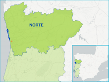
    The FLAG area is located on the Atlantic coast in the north of Portugal and covers 12 local administrative units in three municipalities. These municipalities have traditionally had strong economic, social and cultural links with the sea (fishing, fish markets, fish processing, canning, aquatic and nautical sports and seafood restaurants).
  • Litoral Norte FLAG

    29/12/2016
    - Fiches FLAG
    Located in the north of Portugal, the Litoral Norte (North Coast) is part of the Alto Minho region (NUT III), which is composed of 25 communes that make up five coastal and inland municipalities (Braga, Viana do Castelo, Caminha, Vila Nova de Cerveira and Valença).
  • Arousa FLAG

    29/12/2016
    - Fiches FLAG
    The FLAG is located in the middle of the north western coastline of Spain facing the Atlantic Ocean. The coastal territory of the Ria Arousa FLAG is a horseshoe-shaped area around the wide mouth of the tidal river of the same name and includes a number of islands.
  • Pontevedra FLAG

    28/12/2016
    - Fiches FLAG
    The area forms a geographical entity around the mouth of the Lérez River in the South West of Galicia, which flows into the Atlantic Ocean at the city of Pontevedra, where it creates Pontevedra's ria, having 6 municipalities. The boundaries are characterised by natural landmarks: The Lanzada isthmus in the North, the Cabo Udra in the South, the islands Ons and Onza in the West.
  • Vigo – A Guarda FLAG

    28/12/2016
    - Fiches FLAG
    The FLAG area covers 11 municipalities in the south of Galicia and is bordered by Portugal to the south. It includes Vigo, the biggest city in Galicia and the largest fishing harbor in Spain. There are 12 other ports in the area mainly in the north (with 10 auctions and 4 marinas). In the north, fishing is an important activity, whereas to the south, shellfish activities, processing and canning.
  • Wagrien-Fehmarn FLAG

    28/12/2016
    - Fiches FLAG
    The FLAG is located on the Baltic coast of Schleswig-Holstein. It covers the eastern part of the Wagrien peninsula and Fehmarn, the third biggest island in Germany. Fehmarn is linked to the mainland by the Fehmarnsund bridge and has the most used ferry connection for both the Germans and Danes to the nearby port of Rødby on the island of Falster in Denmark, lying on the Hamburg-Copenhagen axis.
  • Dumfries & Galloway FLAG --ARCHIVED as of 31 January 2020--

    28/12/2016
    - Fiches FLAG
    --ARCHIVED as of 31 January 2020-- The FLAG area is distinguished by its intrinsic remoteness and natural beauty, illustrated by the high number of wildlife and landscape designations along the coast. The FLAG covers approximately 290 miles (467km) of coastline from Cairnryan in the East to Gretna in the West and includes the port at Kirkcudbright is which is in the top 20 UK ports by catch value.
  • Outer Hebrides FLAG --ARCHIVED as of 31 January 2020--

    28/12/2016
    - Fiches FLAG
    --ARCHIVED as of 31 January 2020-- The Outer Hebrides is a chain of more than 100 islands and skerries located about 70 kilometres north west of mainland Scotland, of which 15 are inhabited. The Outer Hebrides Fisheries Area is defined using the Comhairle nan Eilean Siar Local Authority area which is has the same boundaries as many other organisations including the Outer Hebrides Inshore Fisheries Group.
  • Orkney Islands FLAG --ARCHIVED as of 31 January 2020--

    27/12/2016
    - Fiches FLAG
    --ARCHIVED as of 31 January 2020-- Orkney is made up of 70 islands, 18 of which are inhabited. Orkney is both a rural and island community, and economy, in an extremely peripheral location off the North coast of Scotland, which gives rise to a unique mix of opportunities and challenges. The whole of the Orkney Islands’ are included in the FLAG area.
  • Bornholm FLAG

    27/12/2016
    - Fiches FLAG
    The FLAG area covers the entire island of Bornholm, located in the Baltic sea to the east of the rest of Denmark and to the south of Sweden. The main industries on the island include fishing, dairy farming, and during the summer, tourism. The island’s heritage is characterised by crafts such as glass production and pottery, and a particularly large amount of round churches.