FARNET
Fisheries Areas Network
FLAG Factsheet

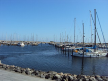
The coastal and inland rural area of Wagrien-Fehmarn is located on the Baltic coast of Schleswig-Holstein. It covers the eastern part of the Wagrien peninsula and Fehmarn, the third biggest island in Germany. Fehmarn is linked to the mainland by the Fehmarnsund bridge and has the most used ferry connection for both the Germans and Danes to the nearby port of Rødby on the island of Falster in Denmark, lying on the Hamburg-Copenhagen axis.
Wagrien-Fehmarn is an “Aktiv-Region”, a status used in Schleswig-Holstein for territories implementing the EAFRD and also, in part, the EMFF-funded local development strategies (LDS). It is, therefore, both a LEADER LAG and a FLAG.
As the Wagrien-Fehmarn area is predominantly coastal, the eligible area for the FLAG is only a little smaller than the one for LEADER. For the 2014-2020 funding period, the FLAG has expanded its coverage to all coastal municipalities of the Aktiv-Region area.
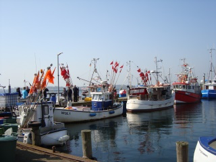
In general, the FLAG area is strongly influenced by tourism, in particular by Baltic Sea coastal tourism at seaside resorts. Fishing is carried out by coastal boats in the Baltic Sea with cod, herring, sprat, sea trout and various flatfishes being the main target species. Some larger vessels from Heiligenhafen also operate in the Skagerrak, Kattegat and in the North Sea. Most of the catch is landed in Heiligenhafen and Fehmarn. However, the majority of the catch is sent unprocessed to auctions in the Netherlands and Denmark.
The challenges for the fisheries sector include the shortage and endangerment of fish stocks (including the eel), seasonal restrictions linked with the protection of the natural environment (Natura 2000) and with the types of gears allowed (gillnetting), the limited presence of fisheries and the progressive obsolescence of the fleet.
The area includes HELCOM Marine Protected Areas (Fehmarn West with Orther Bucht and Flügger Sand), other nature conservation areas, landscape protection and bird protection areas as well as Natura 2000 areas.
The FLAG strategy was developed in connection with the integrated development strategy of the Aktiv-Region for LEADER.
The FLAG strategy pursues the following goals:
The FLAG strategy focuses on five main themes including:
The co-financing for the implementation of the strategy (projects) is provided by the municipalities, towns and the county. The federal land of Schleswig-Holstein provides the co-financing for running costs and animation (not included in the budget figures).
Projects can be presented on an ongoing basis to the decision-making body of the FLAG, the “Arbeitskreis Fischerei” which meets regularly as a working group. Project selection meetings are scheduled when needed.
Calls are published here:
The FLAG area has a long tradition of fishing and tourism.
There is a high interest shown by the fishermen in the development of pesca-tourism in the region, as well as exchanging and cooperating in this area of expertise.
The FLAG is interested to cooperate with other German FLAGs located in the Baltic Sea.
The FLAG shares its territory with the greater part of that of the LEADER-region Wagrien-Fehmarn LAG, as it forms the area’s coastline.
It operates under the same association as the LAG (LEADER), which functions as the “overarching LAG”. The autonomous FLAG decision-making body is at the same time a working group of the LAG.

The chairman of the decision-making body is also member of the board in the LEADER LAG. He reports to the LAG board on the projects and the activities.
The FLAG strategy is strongly interlinked with the integrated (LEADER) strategy of the “overarching LAG”, complementing it for the fisheries part. The strategies remain separate documents.
The FLAG/LAG coordinates its work with the neighbouring LAGs/FLAGs in Schleswig-Holstein through intensive contacts.
The member organisations of the General Assembly of the LAG are:
The FLAG decision-making board consists of representatives from:
The number of individuals/organisations in the partnership or the general assembly is variable.