FARNET
Fisheries Areas Network

Spain

  • Catering company set up by a barnacle gatherer and his mother

    02/10/2017
    - Good Practice Short Story
    Playa del Aguilar is a renowned beach and highly attractive touristic point on the Asturian coast. The village triples its population over the summer months, from 5 000 to 15 000 and the sandy beach and modern seafront are visited daily by thousands of tourists, summer residents and locals. However, in the vicinity of the beach, there are few restaurants or shops where tourists can buy ready-made food.
  • FLAG collaborates with a microcredit institution to support new local businesses

    15/09/2017
    - Good Practice Method
    The Eastern Cantabria FLAG has partnered with a local microcredit institution in assessing business plans to help community members obtain loans to launch new companies in its area.
  • El Hierro FLAG

    12/09/2017
    - FLAG Factsheet
    El Hierro is the smallest and most westerly island of the Canary archipelago. The FLAG area consists of the municipalities of La Frontera, El Pinar and Valverde, covers an area of approximately 270km2, and has a population of 10 000.
  • Tenerife FLAG

    12/09/2017
    - FLAG Factsheet
    The FLAG area covers the 342km coastline of Tenerife which varies from rocky cliffs to low coastline and beaches. Tenerife is very much geared around tourism but there are many activities that utilise the island’s coast and marine space. Employment levels are good in the coastal area and fishing and aquaculture account for 3.4% of the island’s total employment and around 2% of its GDP
  • La Palma FLAG

    12/09/2017
    - FLAG Factsheet
    La Palma is one of the Canary Islands located in the Atlantic Sea. The FLAG consists of 14 municipalities, covers an area of approximately 710km2, and has a population of roughly 80 000 inhabitants.
  • La Gomera FLAG

    12/09/2017
    - FLAG Factsheet
    The FLAG covers the municipalities of Hermigua, Vallehermoso, Valle Gran Rey, San Sebastián, Agulo, and Alajeró, covers an area of approximately 370km2 and has a population of 21 000.
  • Fuerteventura FLAG

    12/09/2017
    - FLAG Factsheet
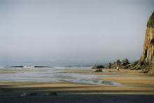
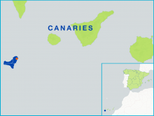
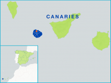
    The island of Fuerteventura is the second largest of the Canary Islands and includes the 4.8Km2 islet of Lobos. It has a low, sandy coastline resulting from intense erosion. The activities that traditionally occupied the local population (agriculture, including cattle farming, and fishing) now provide employment to scarcely 1.2% of the population, while three quarters of jobs are linked to the service sector, and in particular tourism.
  • Noroeste de Cádiz FLAG

    12/09/2017
    - FLAG Factsheet
    The Noroeste de Cádiz FLAG area consists of five municipalities: Trebujena, Sanlúcar de Barrameda, Rota, Chipiona and Puerto de Santa María. Fishing activities (trawling, seining, shell-fishing) are widespread throughout the area where there are several fishing ports and catches are sold at fish auctions daily.
  • Lanzerote FLAG

    12/09/2017
    - FLAG Factsheet
    Lanzarote, also known as “the island of volcanos”, is made up of seven municipalities and a small archipelago to the north of the island (Chinijo Archipelago). The whole area has been classified as a UNESCO Biosphere Reserve.
  • Gran Canaria FLAG

    12/09/2017
    - FLAG Factsheet
    The FLAG covers the coastline of Gran Canaria, the most populated of the seven Canary Islands. Tourism is the main engine of Gran Canaria’s economy, 63% of which is divided between the retail trade and the restaurant sector.