Lithuania has a relatively short coastline of sandy beaches on the Baltic Sea. The 12 Lithuanian FLAGs aim to diversify the economy of certain fisheries communities, while taking advantage of the natural and cultural heritage.
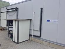
The development of small-scale fisheries and aquaculture businesses in the Western Lithuania FLAG area is a vital part of the economic development of regions such as Klaipeda and Priekulė. This project, implemented by a small local company, aims to improve the processing of local fisheries and aquaculture products through a series of FLAG-funded strategic investments.
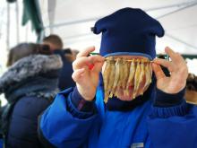
A cooperation project promoting fishing heritage, strengthening local traditions and increasing the consumption of forgotten freshwater fish species.
More information available in EN, LT, DA, FI, EL, FR
FLAGs in Lithuania can choose whether to take advantage of the opportunity to cooperate with other groups, in which case, they choose the themes that are most relevant to them.
The FLAG is situated in the western part of Lithuania, near the Curonian Lagoon. The region is well known for covering a large variety of water bodies and is aptly called ‘the land of four waters’ as a result. As well as the Curonian Lagoon, these waters also include the Baltic Sea it is surrounded by the Baltic Sea and several lakes, rivers, ponds, quarries suitable for recreational fishing.
The Šiauliai FLAG area has a high potential for the development of tourism and recreational activities. Situated in the North of Lithuania, it has a rich cultural heritage and numerous natural monuments. The region has a wealth of inland waterways and ponds which are ideal for the creation and development of fisheries and aquaculture, recreational fishing activities and water sports.
The Ignalina FLAG territory is situated in the east of Lithuania, a region characterised by its many lakes and forests. As such, it has a high potential for the development of recreational, tourism and sports activities. Lakes occupy about 7.7% of the area, forests are about 33.7%, and woodland swamps approximately 10.7%.
The Utena FLAG is situated to the east of Lithuania and is close to the Latvian border. The area has a naturally rich environment and comprises many lakes, forests, ponds, rivers, and streams and is a popular destination for national and international tourists. There are 182 lakes throughout the region making it a popular destination for water sports, cultural excursions and eco-tourism.
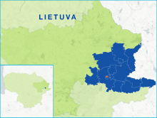
The Zarasai and Visaginas region local action group is located in the north-east of Lithuania, in Utena county, on the border with Latvia and Belarus. The LAG territory is extremely rich in nature and pine woodland occupies nearly 30% of the LAG territory (around 51 thousand ha). 12.2% of the area is covered by around 300 water bodies. The total area of water bodies is about 13 000 ha.