FARNET
Fisheries Areas Network

Greece

  • Developing a knowledge hub on Marine Protected Areas

    05/07/2018
    - Cooperation Idea
    The Cyclades FLAG, Greece, is looking for partners to build a practical working group on fostering socio-economic development around MPAs. The idea is to bring together Mediterranean FLAGs that are home to a Marine Protected Area to exchange and discuss ways to ensure MPAs are successful in protecting biodiversity while remaining economically viable. Participating FLAGs would take turns to organise and host a workshop and case study on the topic, starting in early 2019. Read on for further details.
  • Northern and South East Crete FLAG

    31/10/2017
    - FLAG Factsheet
    The FLAG area includes the most developed area of the island of Crete (North West and North East coastal parts of Heraklion) in terms of tourism. Despite the extensive coastline, fishing is limited to demersal and small pelagic fish species which are promoted to the local fish markets.
  • Crete Messara Gulf FLAG

    31/10/2017
    - FLAG Factsheet
    Due to its extensive history and unique natural environment, this FLAG area which covers the southwest part of Heraklion Prefecture, (Messara Gulf), is rich with cultural and natural assets.
  • Rethymno FLAG

    31/10/2017
    - FLAG Factsheet
    The FLAG area covers parts of Heraklion and Rethymno. The area has significant port infrastructure, fishing harbours and fishing shelters. The fisheries communities have similar social, economic and development characteristics.
  • Samos FLAG

    31/10/2017
    - FLAG Factsheet
    The FLAG territory is made up of a series of small-scale fishing, environmental and touristic areas. The entire area has a long, mostly coastal fishing tradition, which is an integral part of the local culture of these island communities.
  • Pillio FLAG

    30/10/2017
    - FLAG Factsheet
    The FLAG area consists of the Sporades islands, and the community of Trikeri. The morphology, the limited degree of human intervention and the excellent condition of the natural environment, makes the area an ideal refuge for many endangered species.
  • South Evia & Skyros FLAG

    30/10/2017
    - FLAG Factsheet
    The FLAG area is a sub region on the island of Evia which is geographically located in the epicentre of the Greek Mainland. The main challenges in the area are sustainable development, increasing competitiveness, job creation and improving the quality of life.
  • Central and North Evia FLAG

    27/10/2017
    - FLAG Factsheet
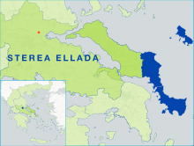
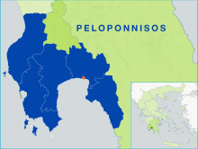
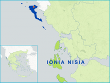
    The FLAG area is part of Evia Island, Greece’s second largest island in terms of size and population after Crete, and located in the centre of Greece. The main challenges for the area include sustainable development, increasing competitiveness and openness, job creation and improving the quality of life.
  • Messinia FLAG

    20/10/2017
    - FLAG Factsheet
    The FLAG area has a strong level of community cohesion. Despite this, they still face issues related to an ageing population. The primary sector is characterised by small-scale fisheries and small-scale agriculture. Tourism is very important for the economy of the region.
  • Ionian Islands FLAG

    20/10/2017
    - FLAG Factsheet
    The island of Corfu lies of the north-west coast of Greece. The local economy is mainly dependant on tourism. The island is known for its natural beauty and pleasant climate. As the only part of Greece not to have been occupied by the Ottoman empire, it has a unique history.