FARNET
Fisheries Areas Network

Germany

  • Heather and pond landscape of Oberlausitz FLAG

    01/09/2017
    - FLAG Factsheet
    The region is one of Germany’s largest commercially operated lake and aquaculture areas. Fishing started here in the middle of the 13th century.
  • Bremerhaven FLAG

    01/09/2017
    - FLAG Factsheet
    The FLAG area “Fischereihafen Bremerhaven“refers to the fishery port of Bremen/Bremerhaven. After 100 years of prosperity, the crisis in deep-sea fishing in the 1970´s and 80´s had a significant impact on Europe´s leading destination for landing and processing of fish.
  • Eastern Oberlausitz FLAG

    01/09/2017
    - FLAG Factsheet
    The Eastern Oberlausitz FLAG is situated in the eastern part of Saxony. This primarily rural region is located between the border with Poland and the conurbation of Dresden (approx.100 km away). The landscape is characterised by many diverse natural areas with rare animal and botanical species.
  • Dresdner Heidebogen FLAG

    01/09/2017
    - FLAG Factsheet
    The FLAG’s territory is situated to the east of Saxony and borders the regions of Dresden to the south and Brandenburg to the north. The eastern part of the area is highly forested, while the west is characterised by a typically European agricultural landscape. Throughout the entire area, pond farming is prevalent.
  • Lusatian Lake District FLAG

    01/09/2017
    - FLAG Factsheet
    The Oberlausitzer Heide und Teichlandschaft in the south of the region is one of the biggest commercially used lakelands in Germany. Here, there are 1,925 hectares of lakes with an economic use.
  • Karpfenland Aischgrund FLAG

    01/09/2017
    - FLAG Factsheet
    The Aischgrund FLAG is strongly influenced by the area’s fishponds. There are currently around 7000 ponds, where approximately 1200 farmers produce 15% of the total carp production in Germany in small-scale fisheries. The carp is not only a significant economic factor but also a significant part of the ecology and the culture with a 1200-year-old tradition
  • Delitzsch area FLAG

    01/09/2017
    - FLAG Factsheet
    The Delitzscher region is situated in the north of Saxony, in western “Nordsachsen” to the north of the city of Leipzig. 72% of the area is used for agricultural purposes and 1,933 ha is covered in water
  • Karpfenland Romantic Franconia FLAG

    01/09/2017
    - FLAG Factsheet
    The FLAG covers the administrative region of Middle Franconia, the largest rural district in Bavaria. Ansbach is the main city in the area which is situated 25 miles southwest of Nuernberg, 90 miles north of Munich and is near the Franconian Lake District.
  • Saxon Zweistromland - East Elbe FLAG

    01/09/2017
    - FLAG Factsheet
    The region is in the northern part of Saxony, close to the border of the federal states of Brandenburg and Saxony-Anhalt; it has a typical agricultural landscape with several protected areas.
  • Karpfenland Middle Upper Palatinate FLAG

    01/09/2017
    - FLAG Factsheet
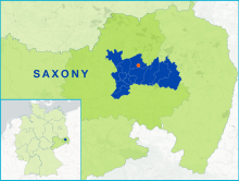
    The FLAG area is situated in the south-east of Germany in Bavaria. It is located 95km east of Nurnberg and close to the Czech border. The area’s natural environment consists of forests and many water resources including traditional ponds, rivers and lakes, which offer many leisure and tourism opportunities, and the area is well connected to nationwide transport.