FARNET
Fisheries Areas Network

Germany

  • Inner Luebeck Bay FLAG

    31/08/2017
    - FLAG Factsheet
    The area is situated in the south-west part of the Baltic Sea. It is a popular tourist destination. The fisheries sector here is still important, though it is generally declining.
  • Hills of the Baltic Sea beach FLAG

    31/08/2017
    - FLAG Factsheet
    The coastal and inland rural area of “Hügelland am Ostseestrand” is located on the Baltic coast of Schleswig-Holstein around the Bay of “Eckernförde”, an important fisheries area. It is close to Kiel; the capital of Schleswig-Holstein and the Kiel canal borders the region in the south.
  • Southern North Friesland FLAG

    31/08/2017
    - FLAG Factsheet
    The fisheries area “Nordfriesland Nord” is located on the west coast of Schleswig-Holstein, just under 20 km from the Danish border. It is a rural region with a strong tourism sector. In the immediate vicinity of the FLAG lie the North Frisian Islands of Sylt, Föhr and Amrum and the numerous Hallig islands (tidal islands). The North Sea in this area is part of the German Wadden Sea National Park of Schleswig-Holstein which is a UNESCO World Heritage Site.
  • Baltic Sea coast FLAG

    31/08/2017
    - FLAG Factsheet
    The FLAG is situated next to the capital city of Schleswig-Holstein, Kiel in the north of Germany and borders the Baltic sea to the west of this city. As a brack water sea, the Baltic offers only a relatively small number of fish species.
  • South Leipzig area FLAG

    19/05/2017
    - FLAG Factsheet
    The FLAG is mainly characterised by widespread former brown-coal mining areas. In many of the opencast pits, artificial lakes have developed, which form a major part of the landscape in the area south of Leipzig in the north-west of the FLAG territory. The long history of mining and its legacy of pollution and environmental hazards are challenges these areas must cope with.
  • Schlei-Baltic Sea FLAG

    19/05/2017
    - FLAG Factsheet
    The FLAG area is located in the North East of Schleswig Holstein on the Baltic Sea and is crossed by the River Schlei and its estuary. Both on the coast and on the river, there is strong fisheries tradition here.
  • Steinburg FLAG

    17/05/2017
    - FLAG Factsheet
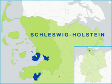
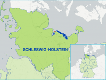
    Glückstadt is a town in the Steinburg district of Schleswig-Holstein, Germany. The FLAG area consists solely of the municipality of Glückstadt and is part of the LAG AktivRegion of Steinburg. Due to its location on the Elbe river on the way to Hamburg, its long tradition lies in fish processing, mainly herring, which is not caught in the FLAG area.
  • Dithmarschen FLAG

    16/05/2017
    - FLAG Factsheet
    The county of Dithmarschen is a rural and coastal area located on the west coast of Schleswig-Holstein. Within this area, the fishing communities of Büsum, Friedrichskoog, Marne and the municipality of Wöhrden, form the territory covered by the FLAG.
  • Northern North Friesland FLAG

    16/05/2017
    - FLAG Factsheet
    The fisheries area “Nordfriesland Nord” is located on the west coast of Schleswig-Holstein, just under 20 km from the Danish border. It is a rural region with a strong tourism sector. In the immediate vicinity of the FLAG lie the North Frisian Islands of Sylt, Föhr and Amrum and the numerous Hallig islands (tidal islands).
  • Tirschenreuth / Land of a thousand ponds FLAG

    17/01/2017
    - FLAG Factsheet
    The Land of 1000 Ponds is in the Northeast of Bavaria, close to the border with Western Bohemia in the Czech Republic. It is one of the oldest agro-cultural landscapes in Europe and is formed by more than 4 700 fish ponds, some of which have been verified as being more than 800 years old.