FARNET
Fisheries Areas Network

France

  • Saint-Brieuc FLAG

    24/05/2017
    - FLAG Factsheet
    The FLAG area is typical of Northern Brittany, combining a succession of rocky coastline, bays, river estuaries and marshes, as well as coastal towns strongly connected to a dynamic maritime environment. A great variety of ecosystems and scenery compose this area which is greatly influenced by the strong tides and harshness of the sea.
  • Côte d’Emeraude – Rance – Baie du Mont Saint-Michel FLAG

    24/05/2017
    - FLAG Factsheet
    The Côte d’Emeraude – Rance – Baie du Mont Saint-Michel area surrounds the Rance river estuary. It is characterised by very contrasted landscapes: rocky shores, small rias stretching inland, marshes and polders. The territory relies on tourism, agriculture and maritime activities.
  • Brest FLAG

    11/04/2017
    - FLAG Factsheet
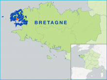
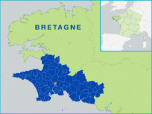
    The FLAG area is located on the western tip of the Brittany peninsula, covering a range of urban, rural and coastal environments. Its important urban centre, the Brest Metropolis is home to the second biggest military port in France. However, with over 600 km of coastline, the area is overwhelmingly defined by its maritime identity.
  • Arcachon FLAG

    31/03/2017
    - FLAG Factsheet
    The Arcachon – Val de l’Eyre basin is a semi-closed bay where many marine activities take place, and in particular tourism, which is the key activity for the local economy. Fisheries and aquaculture are also important sectors in the area.
  • Marennes Oléron FLAG

    17/03/2017
    - FLAG Factsheet
    The Marennes Oléron FLAG covers a rural and coastal territory whose natural and agricultural landscapes represent 85% of the area (40% of which are marshes). Tourism and primary sector activities are important components of the local economy, along with services and commercial activities.
  • Cornouaille FLAG

    03/03/2017
    - FLAG Factsheet
    Cornouaille, on the western part of Brittany, has a 330km coastline along the Atlantic Ocean. The FLAG area counts 130 000 jobs and its key industries include food processing, tourism and commercial fisheries. 20% of the fish landed in French ports is landed in Cornouaille
  • FARNET Guide 11 cover

    FARNET Guide #11: Results-oriented CLLD in fisheries areas: six practical factsheets

    25/12/2016
    - Publication
    This guide is composed of six factsheets, including real-life examples, designed to help FLAGs ensure better results through developing strategic objectives, selecting indicators and setting targets, collecting data and managing information, and adopting a results-oriented approach in all activities of the FLAG.
  • FARNET Guide 10 cover

    FARNET Guide #10: Starting CLLD implementation in practice

    25/12/2016
    - Publication
    This guide presents examples of applying CLLD under the different ESI Funds: EMFF, EAFRD, ESF and ERDF from the perspective of Managing Authorities and local actors.
  • gac_logo

    New start-up company models for young unemployed people

    21/11/2016
    - Cooperation Idea
    The North Sardinia FLAG wishes to cooperate with FLAGs concerned with new start-up models led by young people, fishermen’s relatives or young people leaving secondary schools who want to create self-employment opportunities.
  • FARNET logo

    Lessons from FARNET 1 (2007-2013)

    09/09/2016
    - Basic page
    The experience developed by FARNET under Axis 4 of the EFF (2007-2013) is still highly valuable for the current programming period, especially for new FLAGs.