FARNET
Fisheries Areas Network

European Union

  • Pontevedra FLAG

    28/12/2016
    - FLAG Factsheet
    The area forms a geographical entity around the mouth of the Lérez River in the South West of Galicia, which flows into the Atlantic Ocean at the city of Pontevedra, where it creates Pontevedra's ria, having 6 municipalities. The boundaries are characterised by natural landmarks: The Lanzada isthmus in the North, the Cabo Udra in the South, the islands Ons and Onza in the West.
  • Vigo – A Guarda FLAG

    28/12/2016
    - FLAG Factsheet
    The FLAG area covers 11 municipalities in the south of Galicia and is bordered by Portugal to the south. It includes Vigo, the biggest city in Galicia and the largest fishing harbor in Spain. There are 12 other ports in the area mainly in the north (with 10 auctions and 4 marinas). In the north, fishing is an important activity, whereas to the south, shellfish activities, processing and canning.
  • Wagrien-Fehmarn FLAG

    28/12/2016
    - FLAG Factsheet
    The FLAG is located on the Baltic coast of Schleswig-Holstein. It covers the eastern part of the Wagrien peninsula and Fehmarn, the third biggest island in Germany. Fehmarn is linked to the mainland by the Fehmarnsund bridge and has the most used ferry connection for both the Germans and Danes to the nearby port of Rødby on the island of Falster in Denmark, lying on the Hamburg-Copenhagen axis.
  • Bornholm FLAG

    27/12/2016
    - FLAG Factsheet
    The FLAG area covers the entire island of Bornholm, located in the Baltic sea to the east of the rest of Denmark and to the south of Sweden. The main industries on the island include fishing, dairy farming, and during the summer, tourism. The island’s heritage is characterised by crafts such as glass production and pottery, and a particularly large amount of round churches.
  • Halsnæs-Gribskov FLAG

    27/12/2016
    - FLAG Factsheet
    The Gribskov FLAG area is situated in the north of the island of Sealand. It includes the city of Gilleleje, a lively commercial centre, which is home to the region’s largest fishing port and only fish auction. The city is also an important visitor destination, with tourism and fishing being the main economic sectors in the FLAG area. Except for herring, all the fish landed in the area is exported and not processed locally.
  • Djursland FLAG

    27/12/2016
    - FLAG Factsheet
    The FLAG area covers the entire municipality of Norddjurs, which is notable for its long coastline, made up of sandy beaches – like much of the Danish coastline. This flat coastal landscape attracts tourists from Norway and Germany – as well as domestic visitors. Tourism is the area’s dominant sector. Fishermen struggle now to make a living, but there has been an increase in the number of small businesses processing seaweed, for both food and nonfood uses.
  • Jūrkante FLAG

    27/12/2016
    - FLAG Factsheet
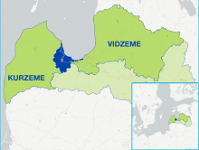
    The Jūrkante FLAG is situated in the northern part of Latvia and stretches for about 61 km along the Gulf of Riga coast, from Skulte to Ainaži. The FLAG covers two towns (Ainaži, Salacgrīva) and two municipalities made up of six parishes (Ainaži, Salacgrīva, Liepupe, Pāle, Skulte and Viļķene).
  • Sernikon FLAG

    27/12/2016
    - FLAG Factsheet
    The FLAG area is located in the metropolitan area of Riga, the capital of Latvia. It includes two municipalities, Carnikava and Saulkrasti. The area has a 35 km coastline along the Gulf of Riga and is renowned for its rich biodiversity and the landscape of the “Piejūra” Nature Park. This combination of elements provides considerable potential for the development of tourism and other related businesses.
  • Laukiem Jūrai FLAG

    26/12/2016
    - FLAG Factsheet
    The FLAG is situated in the central part of Latvia close to the capital city – Riga. It covers around 75 km of the coastline along the Gulf of Riga. The area has notable inland water sources like the Engure, Kaņieris, Sloka and Valgums lakes. The coastal area has a well-developed fish processing (14 enterprises that employ around 800 people) and tourism sectors (66 enterprises that count for over 200 jobs).
  • North Kurzeme FLAG

    26/12/2016
    - FLAG Factsheet
    The Northern Kurzeme FLAG is located in northwest Latvia. The area is bordered by a 144 km stretch of the Baltic coast, from the parish of Jurkalne to the Cape of Kolka, and 12 km of the coastline around the Gulf of Riga. It includes Ventspils, one of the nine development centres of national significance in Latvia. There are two important fishing ports – Roja and Ventspils.